Why investigate Cockatoo Sands?
Cockatoo Sands are recognised as having potential for irrigated agriculture because they are much better drained than the ‘black soils’ of the Ord River Irrigation Area (ORIA). This means that they can be cultivated and planted either at the start of the wet season or much earlier in the dry season than most of the soils of the ORIA. Consequently, developing Cockatoo Sands may provide the opportunity to grow multiple crops during the year and also to grow a broader variety. This would also provide the opportunity for more efficient usage of available plant, equipment and labour resources in the Kununurra area.
Our assessment program
Areas surveyed during this investigation were identified from reconnaissance soil mapping of about 50 000 hectares (ha) of Cockatoo Sands and associated soils in 2009. This investigation is described in Resource management technical report 364 'Cockatoo sands soil survey: assessment of the potential irrigation areas, Kununurra area, East Kimberley'.
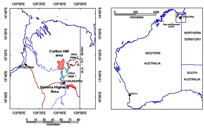
Resource management technical report 391 'Cockatoo Sands in the Victoria Highway and Carlton Hill areas, East Kimberley: land capability assessment for developing irrigated agriculture' describes the results of a more-detailed assessment of 2 areas that have high potential for irrigated agriculture (Figure 1):
- Victoria Highway area, which is about 3000ha along the Victoria Highway, centred 15km south of Kununurra
- Carlton Hill area, which is about 7000ha north of Carlton Hill Road, about 15km north of Tarrarra Bar, Ord River.
Both areas contain mainly Cockatoo Sands but also have inclusions of red clay soils that could potentially be developed for irrigated agriculture. Because both areas are relatively close to the Ord River or the existing ORIA irrigation channel system, they also have the potential to be irrigated via pipelines from these water sources.
In addition, another area — termed the Bonaparte Plains — comprising about 30 000ha of Cockatoo Sands and situated about 50km north of the ORIA, is being assessed for potential groundwater resources.

What did we find?
Soil characteristics
Soil analysis of Cockatoo Sands found no chemical or major physical limitations that would preclude the use of these soils for irrigated agriculture, excepting the normal requirement to apply sufficient plant nutrients for optimal growth. Soil tests of Cockatoo Sands from established horticultural blocks indicate minimal change to soil characteristics over time, suggesting that existing management practices can result in sustainable production.
Soil factors that would need to be considered with development include the low buffering capacity of the topsoil horizons, the potential increase of soil acidity over time and the potential decline of calcium–sodium ion ratios. These factors can be controlled through fertiliser management and amelioration with gypsum. Structureless sandy and loamy subsoils are prone to compaction under repeated cultivation and will require periodic deep-ripping under annual agriculture.
Cockatoo and Pago soils are generally well drained, are vulnerable to soil erosion under high rainfall, and Pago soils could leach nutrients under intensive horticulture that may lead to eutrophication of water systems.
Areas with potential for irrigated agriculture
This investigation identified 2490ha of Cockatoo Sands, situated 15km south-east of Kununurra and bordering Victoria Highway, as having the most potential for irrigated agriculture. About 4110ha of Cockatoo Sands, occurring in several parcels of land, were also identified north of Carlton Hill Road about 5km north-east of the existing ORIA Stage 1 area (Figure 1). Both locations are about 10km from the Ord River or ORIA water supply channels, and both areas will require a reticulated water supply because groundwater yields are too low to support development of commercial irrigated agriculture.
This investigation also identified about 2370ha of Pago soils at Carlton Hill, which could be used for broadscale fodder cropping or perennial crops that can use subsoil water. These sands and sandy earths, which have subsoils that are less permeable than the Cockatoo Sands, are less suited to intensive annual horticulture, because they are likely to develop perched watertables under high irrigation rates.
About 1400ha of the Carlton Hill area contains red loamy duplex and red loamy earth soils, termed Packsaddle soils, which have a fair potential for irrigated agriculture.


