Why we carried out this assessment
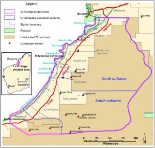
We carried out this assessment as part of the La Grange project, to provide land and groundwater data to support potential irrigated agriculture and sustainable development of land within the La Grange area (Figure 1).

What we did
We assessed areas of Pindan country along the Great Northern Highway, south of Broome from Roebuck to Mandora, which have high potential for irrigated agriculture. The locality is referred to by government agencies as the La Grange area and it covers about 750 000 hectares (Figure 1).
We surveyed soil and land of the La Grange area adjacent to the Great Northern Highway between Roebuck Plains and Mandora. The survey area extended south about 350 kilometres from the Broome turn-off to the Kidson Track and 10–30 kilometres either side of the Great Northern Highway, depending on the availability of access roads and tracks.
Steps in the assessment were:
- confirming the scope of the assessment
- assessing previous soil and land studies of the area
- describing the physiography, geology and climate
- carrying out the soil and land survey
- reviewing and analysing the data
- assessing the land capability for agriculture.
What we found
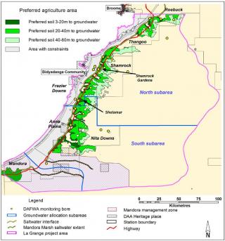
The land capability assessment process identified about 366 000 hectares of Pindan soil with a high to fair capability for irrigated agriculture. Of this area, 50 000 hectares has water suitable for irrigation within 20 metres of the surface and has significant potential for irrigated agriculture (Figure 2). This land area far exceeds the potential irrigable area of 5 000–10 000 hectares that could be developed on the current sustainable groundwater allocation of 50 gigalitres per year.
Future large-scale irrigation projects should be preferably located east of the Great Northern Highway to minimise the potential risk of saltwater intrusion and impact on wetland ecosystems.

Land with fair to high capability for irrigated agriculture
The areas with the highest potential occur within the sandy and loamy Pindan, sandy and loamy Pindan over clay loam substrate, sandy Pindan and sandy Pindan over gravelly alluvium soil-landscape map units, and contain mainly Cockatoo Sand, normal phase and Cockatoo Sand, loamy phase soils.
These map units have a land capability class of 2–3, provided that slopes are less than 1% and drainage lines are not cleared. Existing horticultural developments of up to 500 hectares on these map units are productive and sustainable.
Larger irrigation enterprises may experience significant recharge and rising watertables on some of the soils in the areas classed as suitable for irrigation development. To deal with this, we recommend that developers:
- retain drainage lines under native vegetation for land developments greater than about 500 hectares
- keep vegetation buffers of at least 200 metres wide adjacent to drainage lines and wetlands
- incorporate soil conservation measures on areas with slopes greater than 1% to minimise the risk of soil erosion. Measures could include grade banks, strip planting and cover-cropping.
Developers following these recommendations can minimise potential risks arising from horticultural development. Common risks are eutrophication through seepage and run-off, sedimentation from possible soil erosion and dust from cultivation.
Land with low capability for irrigated agriculture
Large areas of sand dune Pindan have a low capability for irrigated agriculture because of the high risk of wind erosion associated with dune topography and the loose consistency of the fine- to medium-grained topsoils. Broad interdune areas can have a fair capability for irrigated agriculture if conservation measures are employed to reduce the risks of wind and water erosion.
Gravelly Pindan and gravelly Pindan over limestone have a low capability for irrigated agriculture. These areas are generally exposed to the prevailing winds and usually have slopes greater than 2%, which are more prone to water erosion. Soils within these areas are more variable and include gravels, stone and rock outcrop, which are major limitations to cultivation.
Soil drainage, secondary salinity and eutrophication are major hazards for horticulture development in areas of wet Pindan and alkaline clay, which is why these areas should not be developed for irrigated agriculture.
Areas of wet Pindan should also be excluded to minimise impacts on adjacent wetlands. Wetlands are critically important for biodiversity and have a high cultural significance for Indigenous custodians.
Acknowledgements
We carried out this assessment as part of the Regional Economic Development Water Opportunities Project, which aims to promote agribusiness through the development of land and water resources within the Kimberley.
This land assessment was made possible by Royalties for Regions funding.


