The study area
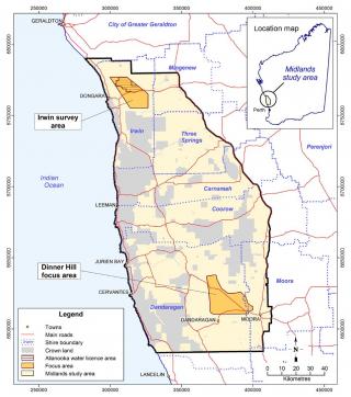
Figue 1 shows the location of the Irwin and Dinner Hill study areas.
Dinner Hill and Irwin soil and land investigations
We assessed the suitability of soils for irrigated agriculture at the Irwin and Dinner Hill focus areas.
At Dinner Hill, most of the soils have moderate to high capability for annual and perennial irrigated agriculture.
At Irwin, the sandy slopes have moderate suitability for irrigated agriculture, but the clay soils are not suitable because of the high risk of salt build-up and soil structure decline, particularly with lower quality irrigated water.
For more information download the 2 reports:
- Soil capability assessment for expanding irrigated agriculture in the Dinner Hill focus area, Midlands, Western Australia – RMTR 406 (PDF 7.4MB)
- Soil capability assessment for expanding irrigated agriculture in the Irwin focus area and surrounding lands – RMTR 408 (PDF 3.4MB)
Irwin hydrological risk assessment
At the Irwin focus area, we investigated groundwater characteristics to explore risks associated with irrigated agriculture.
East of the Gingin Scarp
The eastern part of the focus area is unsuitable for irrigated horticulture.
Groundwater has been consistently rising in the Irwin River valley east of the Gingin Scarp in the Arrowsmith Hydrozone. This trend and shallow depth to groundwater poses a significant risk of dryland salinity developing in this landscape. Rising saline groundwater makes the eastern part of the focus area unsuitable for irrigated horticulture.
West of the Gingin Scarp
Irrigation in the western part of the focus area may cause rising watertables and salinisation.
Surface soils to the west of the Gingin Scarp are not salt-affected, but there is significant salt storage at depth, starting from about 3m down to 7–10m. Groundwater is not rising in this area, and the regolith salt storage is not a hazard for dryland agriculture. However, if irrigation water is applied and groundwater rises, surface salinity is likely to increase.
For more information download the report:
- Hydrological hazard assessment for irrigated agriculture in the Irwin focus area – RMTR 407 (PDF 4.1MB)
Crop suitability for the Midlands area
We found that a wide range of horticultural crops would suit the combination of climate and soils in the Midlands area.
Constraints to a developing horticultural industry
- High summer temperatures and a general lack of market advantage means that most vegetables should be produced during the cooler months of the year.
- Frost-sensitive crops should be confined to areas with a low frost risk, which are generally close to the coast.
- Strong wind is characteristic of the area, and protection against prevailing winds will be required for many crops.
- Suitable water for extensive irrigated horticulture is limited in the study area; Groundwater prospectivity in the Midlands area contains more information on groundwater availability.
For more information download the report:
- Crop and climate suitability for irrigated agriculture in the Midlands area of Western Australia, 2nd edition – RMTR 415 (PDF 1.8MB)
Acknowledgements
Funding through Royalties for Regions made these investigations possible. The Department of Primary Industries and Regional Development, through the Midlands Water for Food Project, conducted these studies that support the expansion of irrigated agriculture in the Northern Perth Basin.

