Our role in the Shay Gap soil survey
In December 2015 the former Department of Agriculture and Food, Western Australia (now the Department of Primary Industries and Regional Development) initiated an assessment of the capability of land for irrigated agriculture in the Shay Gap area.
The Department of Water (now Department of Water and Environmental Regulation) conducted hydrogeological studies to determine the water resources that could be sustainably extracted for irrigation.
The Shay Gap study area
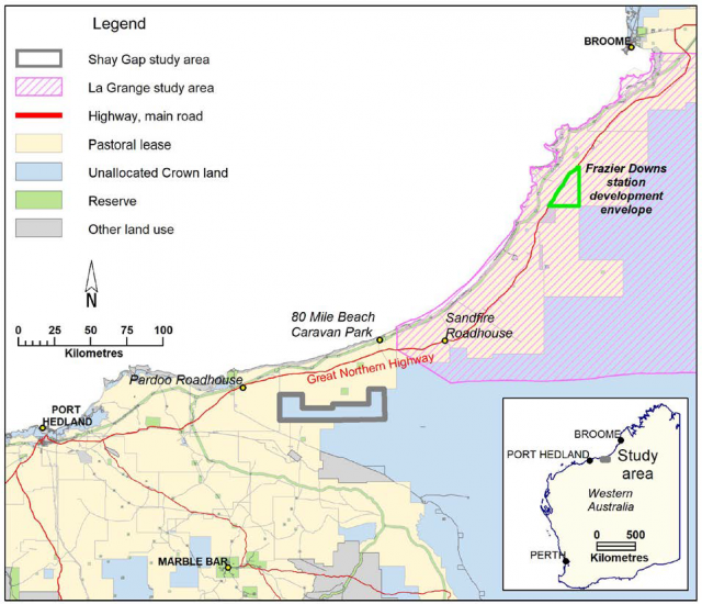
The Shay Gap study area (SA) is about 200 kilometres (km) east of Port Hedland in the Shire of East Pilbara, Western Australia, occupying 88 714 hectares (ha) of unallocated Crown land at the western-most margin of the Great Sandy Desert (Figure 1).
The Shay Gap SA is named after the abandoned mining town of Shay Gap and the remains of the town are about 20km south of the study area’s southern boundary on Boreline Road. We named the study area after Shay Gap (instead of the West Canning Basin SA) to differentiate it from the broader West Canning subregion, which is being investigated for groundwater resources.
What we did
We:
- described the soil and landforms of the Shay Gap SA
- assessed the study area’s capability for 3 types of irrigated agriculture
- examined land resources to ensure future irrigation developments manage risk and do not degrade the environment.
What we found
Climate
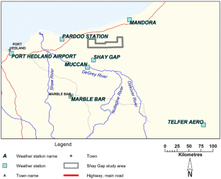
- From October to April inclusive, the mean maximum temperature exceeds 35 degrees Celsius (°C) at Mandora and Pardoo weather stations (Figure 2).
- Extreme temperatures over the summer months can cause heat stress in some agricultural plants, which can result in reduced yield, even with sufficient soil moisture.
- The low-lying coastal zone of the Pilbara is unlikely to meet winter dormancy requirements for horticultural crops that require winter chill.
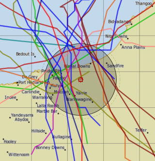
- The Pilbara coastline is the most cyclone-prone region of Australia (Figure 3).
- Dry and intense east to south-east winds from the continental interior are common during the dry season, resulting from subtropical high pressure cells.
- Average annual pan evaporation is about 3500mm, which is about 10 times the average annual rainfall.
Potential for irrigated agriculture
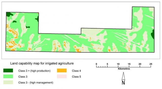
- The north-west quarter of the Shay Gap SA has the most potential for irrigated agriculture, and areas to the north and north-west of the study area are also expected to have significant areas of contiguous soil suited to irrigation. Figure 4 shows the land capability ratings.
- Water erosion, wind erosion, subsurface acidification and nutrient export are the most important land qualities to be managed to maintain resource condition for irrigated agriculture.
- Cropped plants in new irrigation developments need to be chosen on their ability to thrive in very hot summer conditions.
- There is 1430ha of land with a fair capability for irrigated agriculture of high productive capacity (Class 3+, Figure 4) for annual horticulture, perennial horticulture, and fodder and pasture crops.
- There is 11 000ha with fair capability for irrigated agriculture of moderate productive capacity (Class 3, Figure 4), if sufficient water reserves are available.
- Another 45 000ha may be suitable for irrigated agriculture with careful planning, a high level of risk management, and sufficient water (Class 3–, Figure 4). The remaining 31 284ha is not suitable for irrigation development.
- We expect that larger areas of similar soils and landforms exist to the north and north-east of the Shay Gap SA; however, these areas were not surveyed because they were outside the scope of this study.
- The productive capacity of most soils of the Shay Gap SA is expected to be limited by the low clay content at depth, resulting in rapid drainage and a low pH buffering capacity. Irrigation practices will need to be precise to avoid excessive deep leaching and nutrient movement off-site.
What this means
There are significant areas of soil in the Shay Gap SA that are capable – to various degrees – of supporting irrigated annual horticulture, perennial horticulture, and fodder and pasture crops. The Department of Water and Environmental Regulation has investigated groundwater resources for irrigation.
The level of detail in this intermediate-scale investigation is suited to defining specific areas that are most capable of supporting irrigated agriculture in a general sense. More-detailed soil assessment and a topographical survey at a scale of 1:10 000 to 1:25 000 that considers intended crops, pastures and production systems should be undertaken prior to embarking on large, intensive irrigation projects. Detailed soil mapping will also aid in developing efficient irrigation schedules.
For more information
Download the Shay Gap soil survey: investigating the suitability of soils and landforms for irrigated agriculture in the western West Canning Basin’, Resource management technical report 411.
Acknowledgements
This work was funded through the Water For Food Royalties For Regions initiative.

