Why we investigated the Weaber Plain surface water characteristics
The Western Australian Government requested us to lead a project supporting a second phase of modelling for the Weaber Plain (Goomig) farmlands.
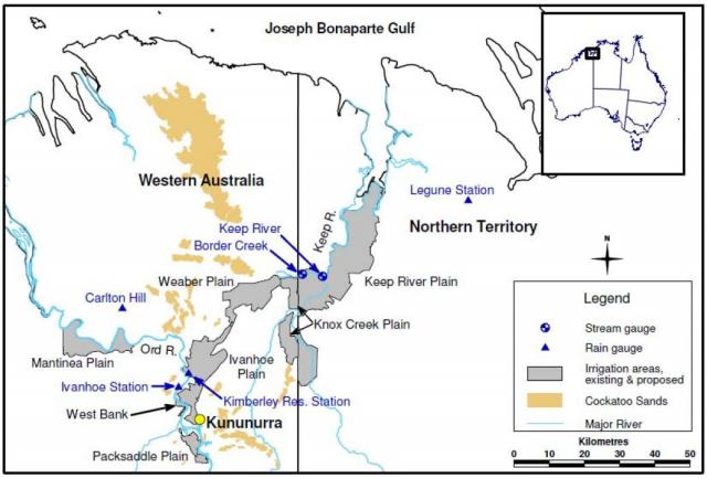
The state government approved the Ord Irrigation Expansion Project in 2008, to develop irrigated agriculture on the proposed 8000-hectare Weaber Plain (Goomig) farmlands, which is located north-east of the existing 14 000-hectare Ord River Irrigation Area, 30 kilometres from Kununurra (see Figure 1).
The main goal of the project was to investigate the potential effect of agricultural development of the Weaber Plain on the water quality of the downstream Border Creek and Keep River, particularly in relation to threatened species – listed as Matters of National Environmental Significance under the Environment Protection and Biodiversity Conservation Act 1999 (EPBC Act) – that inhabit or may inhabit the area.
Possible increases in salinity, nutrients, suspended sediment and farm chemicals delivered in run-off to four perennial river pools in the lower Keep River and the Keep Estuary were of primary interest.
What we did in this project
We:
- analysed climate and rainfall for the area
- reviewed previous investigations:
- water flow data for the lower Keep River and Border Creek systems
- physico-chemical water quality data for the lower Keep River and Border Creek systems
- sampled and analysed water from gauging stations and pools in the lower Keep River and Border Creek systems
- presented data from the initial year of a targeted baseline monitoring program (June 2010 – June 2013)
- compared the data from this project with data from the nearby Ord River Irrigation Area to provide a base for forecasting the project’s impact.
Baseline sediment physico-chemistry, aquatic biodiversity, EPBC Act listed species abundance and macro-invertebrate data were collected in parallel studies.
What we found
The lower Keep River system is highly dynamic and responsive to prevailing rainfall and tidal influences.
We found:
- evidence that dry season flow of the Keep River was changing from an annual flow system to a perennial stream because of groundwater rise as a result of the increase in rainfall since 1993
- the K3 river pool, previously thought to be a fresh aquatic ecosystem, is affected by tidal exchange and saline conditions in the dry season
- that the waterways are better classified as being moderately disturbed, rather than pristine or unmodified, on the basis of the high nutrient and suspended solid concentrations observed, particularly during the wet season.
What this means
The study developed several recommendations:
- develop site-specific trigger values. Although incomplete, data showed that adherence to the ANZECC & ARMCANZ – Australia and New Zealand Environment and Conservation Council, and the Agriculture and Resource Management Council of Australia and New Zealand (2000) – default trigger values (of the major water quality parameters relevant for undisturbed tropical rivers) was not appropriate for the lower Keep River
- develop a coordinated, ongoing baseline water quality monitoring program to suit local conditions (in accordance with ANZECC & ARMCANZ (2000) guidelines) as the basis for developing site-specific trigger values
- continue to use logger and autosampler technology
- focus monitoring and management of stormwater discharged from the proposed farmland development on the late wet season period. Water quality of the final run-off from farms on the Weaber Plain at the end of the wet season flow is likely to be highly important to the health of the river pools in the dry season.
For more information
Full details are in 'Surface water characteristics of the Weaber Plain and lower Keep River catchments: data review and preliminary results', Resource management technical report 370.


