Why we investigated the Weaber Plain hydrogeology
The Western Australian Government requested this department to lead the project supporting a second phase of modelling for the Weaber Plain (Goomig) farmlands.
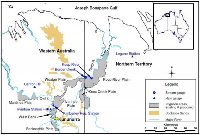
The state government approved the Ord Irrigation Expansion Project in 2008, to develop irrigated agriculture on the proposed 8000ha Weaber Plain (Goomig) farmlands, which is located north-east of the existing 14 000-hectare Ord River Irrigation Area (ORIA), 30 kilometres from Kununurra (Figure 1).
The project began in 2009, with construction of a new irrigation water supply channel connecting the Weaber Plain to the existing ORIA, the final period of irrigation design, and environmental management and related approval processes.
As part of the environmental planning and approvals process, the state government was required to prepare a groundwater management plan and a hydrodynamic plan. These plans were to investigate potential risks of increasing salinity and changed water quality that could result from developing the proposed farmlands, and to specifically use new hazard mapping derived from SkyTEM airborne electromagnetics (AEM) data.
The Weaber Plain groundwater modelling report identified several options to manage watertables and salinity risk (KBR 2010). Both studies also identified that the existing groundwater data was inadequate for evaluating risk and quantifying the impact of options to manage shallow watertables and salinity; that soil and subsoil data was limited; and that downstream impacts required further evaluation.
What we did
The project was divided into 5 phases: 2 addressing deficiencies related to groundwater, 2 relating to soils/subsoils and 1 addressing surface and groundwater quality aspects. Of the issues related to groundwater, uncertainty existed over the location, hydraulic properties and yield of the palaeochannel aquifer and permeability in the northern area of the proposed development where the aquifer was forecast to be absent (Lawrie et al. 2010). Aquifer recharge processes (conceptualisation) and related changes in groundwater dynamics were also to be evaluated.
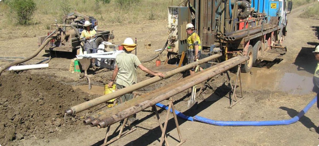
Resource management technical report 366 details the results of the drilling and monitoring undertaken to fulfil Phase 1 (evaluate the aquifer conditions):
1. conceptualisation of aquifer recharge processes
2. location and aquifer characteristics of the palaeochannel
3. location and characteristics of sediments in Border Creek
4. location and characteristics of sediments in the southern Weaber Plain.
What we found
This project found that the major palaeochannel was generally well mapped by interpreted AEM data (Lawrie et al. 2010) and contained high permeability sands and gravels capable of high yields (up to 50 litres per second) from production wells. Drilling confirmed the AEM interpretation of clay-dominated sediments in the north-west, though drilling also identified a discrete calcarenite aquifer in some areas along Border Creek. This calcarenite aquifer is capable of supporting a low-yield wellfield, although it had lower permeability and limited extent in comparison to the palaeochannel.
Groundwater levels were found to be 3–15m below ground within the proposed farmlands. The groundwater was typically low salinity (less than 1100 milligrams per litre [mg/L]) in surficial aquifers, with high salinities (up to 11 000mg/L) measured in deep groundwater and in some areas of shallow basement adjacent to Border Creek.
Analysis of groundwater conditions on the Weaber Plain, downstream of Cave Spring Gap, revealed watertables had risen by 5–10m since monitoring started in 1964. Up until the mid-1990s, localised groundwater level rise was solely attributed to aquifer throughflow and flooding near the Cave Spring Gap (KBR 2010). However, after the mid-1990s, groundwater level rise was observed in areas remote from the influence of the ORIA (Border Creek, Eastern Weaber Plain, Knox and Keep plains). Rainfall analysis indicated that rises in these areas were caused by much wetter than average rainfall since the mid-1990s and the subsequent flooding and recharge.
For more information
Full details are in Resource management technical report 366 'Weaber Plain hydrogeology: preliminary results'.
References
KBR 2010, Weaber Plain groundwater modelling report Stage 1 results, report prepared for LandCorp, Western Australia, Kellogg Brown & Root Pty Ltd, Perth.
Lawrie, KC, Tan, KP, Clarke, JC, Munday, TJ, Fitzpatrick, A, Brodie, RS, Apps, H, Halas, L, Cullen, K, Pain, CF, Kuske, TJ, Cahill, K & Davis, A 2010, 'Using the SkyTEM Time Domain Airborne Electromagnetics (AEM) System to Map Aquifer Systems and Salinity Hazard in the Ord Valley, Western Australia', Geoscience Australia Professional Opinion, 2010/01, viewed 17 October 2018, https://d28rz98at9flks.cloudfront.net/69583/Prof2010_001.pdf


