Why this information is important
Climate change and climate variability have already challenged Western Australian (WA) broadacre cropping and animal production. Producers have met most of these challenges by adopting innovative farming systems to maintain farm productivity and profitability. Future climate change will present further opportunities and challenges for producers.
Records show that over the last century rainfall decreased and temperature increased. Climate projections for the south west of WA are for declining rainfall and higher temperatures.
The grainbelt of WA contributes more than $4.5 billion to WA’s economy each year. Narrogin is situated 192 kilometres south-east of Perth on the southern edge of the central grainbelt. This agri-climate profile provides a historical analysis and projections for a range of climate variables relevant to farm businesses in the Narrogin area.
Changes at a glance
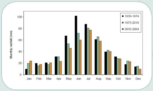
Around the mid–1970s, there was a shift to consistently drier winter conditions in south west WA. Narrogin experienced an 8% decrease in annual rainfall and a 14% decrease in growing season rainfall (April–October) from the period 1931–1974 to 1975–2018.
The observed trends in Narrogin's climate include:
- decline in annual rainfall
- significant decline in winter and growing season rainfall
- fewer very wet years
- more drier-than-usual years
- decline in the number of heavy rainfall events during winter
- more variable and later start of the growing season
- increase in maximum and minimum temperatures.
What the records show
There were shifts in climate for Narrogin in the mid-1970s, then again around 2000. Therefore, the analysis is for the periods from 1931–1974 (43 years), 1975–2018 (43 years) and 2000–2018 (18 years).
Rainfall
Total annual rainfall decreased by 8% in the period 1975–2018 compared to 1931–1974. The growing season rainfall was 14% lower in 1975–2018 and declined a further 10% in the period from 2000–2018. The chance of two consecutive drought years (decile 3 or below growing season rainfall) has increased from 3% in the 1931–1974 period to 8% in 1975–2018.
Around the mid–1970s, there was a shift to consistently drier winter conditions. There was significant decline in June rainfall in the period 1975–2018 compared to 1931–1974.
The reduction in June rainfall resulted from a combination of fewer days with heavy rainfall and generally less rainfall during each rain event.
Temperature
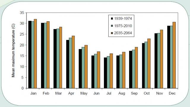
Since the mid-1970s, mean monthly maximum temperatures have significantly increased during April, May, June and July.
Mean minimum temperatures have significantly increased during all months, except January, June and July.
The number of days with maximum temperature above 35 degrees Celsius (°C) has remained relatively unchanged.
The number of frost days (minimum temperature below 2°C) has significantly decreased in May, September and October. The average date of first frost, 30 September, has remained unchanged. Since 2000, the average date of the last frost is 14 October, so the frost risk around flowering continues.
Projected changes
The following projections for the period 2035–2064 were obtained using an intermediate emissions scenario (A2) and downscaled data from the CSIRO Global Climate Model CCAM (CMIP3).
Rainfall
Rainfall projections are for less rainfall during April, May, June and July.

Temperature
Temperature projections indicate the observed trend of increasing mean maximum temperatures will continue.

What are the agronomic implications?
- Since 1975, the start of the growing season has been more variable and generally later. The average start of the growing season, derived from a sowing rule of a sowing window starting from 25 April, has shifted from 16 May for the period 1939–1974 to 18 May for 1975–2010, and 19 May for 2000–2018.
- A later and more variable break of season increases production risk for crops and pastures. Declining autumn rainfall means crops need to be established at the earliest opportunity. Storage and conservation of out-of-season rain is gaining importance. Effective control of summer weeds and stubble is becoming more important.
- The loss of heavy rainfalls in winter has led to reduced reliability of run-off into farm dams. Roaded and natural catchments will need to be 15–20% larger to fill existing dams.
- Declining growing season rainfall and the occurrence of lighter rainfalls has led to greater proportional evaporation losses and less water stored deep in the soil. This increases the risk of moisture stress during crop establishment, flowering and grain filling.
- Declining winter rainfall will reduce production of annual-pasture. Flexible lot-feeding or confined feeding systems may need to be established to maintain or finish livestock. Perennial pastures and native pastures should be viewed as a probable alternative to annual pastures.
What are the options for adapting to climate change?
We provide information and technical support for making changes at the incremental, transitional and transformative levels. A general guide is available for each major enterprise and for soil and water resources:
