Summary
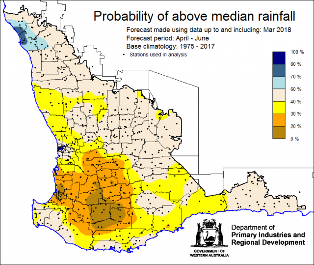
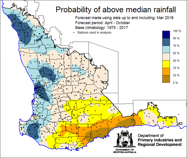
The Department of Primary Industries and Regional Development’s (DPIRD) Statistical Seasonal Forecast (SSF) system is indicating less than a 40% chance of exceeding median rainfall for April to June 2018 for the southern grainbelt and generally 40-60% (neutral) elsewhere. For April to October, the SSF is indicating a mixed outlook with wetter conditions expected for parts of the northern grainbelt.
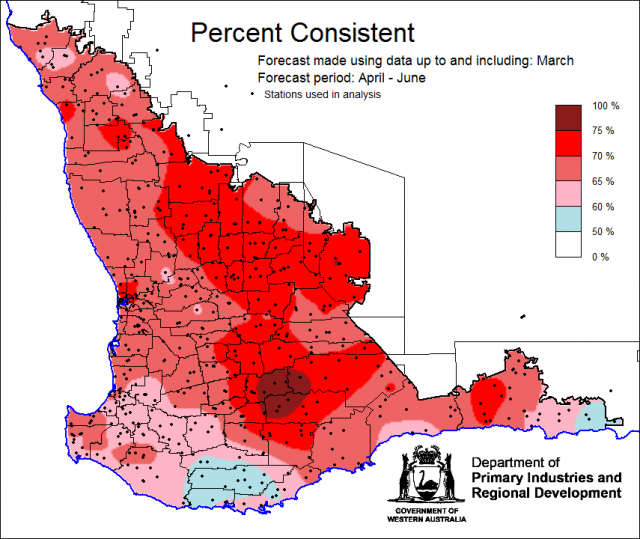
- The SSF is indicating less than a 40% chance of exceeding median rainfall for the southern grainbelt for April to June 2018, with a generally neutral chance (40-60%) elsewhere. The most probable decile range map indicates decile 2-3 rainfall is most likely for southern parts, with decile 4-7 rainfall elsewhere. Predictive skill based on March conditions is poor to good (50-75% consistent).
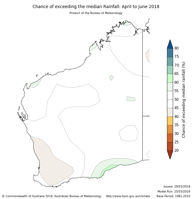
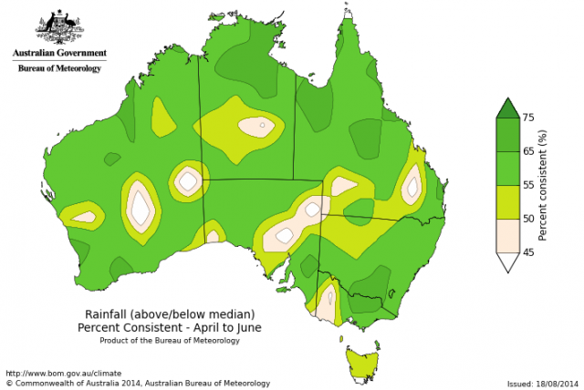
- The Bureau of Meteorology’s current seasonal outlook indicates generally a 40-50% chance of exceeding median rainfall for April to June 2018 for the South West Land Division (SWLD). A neutral outlook (50% chance of exceeding median) does not mean average rainfall is expected. Predictive skill is mostly moderate to good (55-75% consistent). For the individual month of April, the Bureau is indicating a 30-40% chance of exceeding median rainfall for the SWLD. Given this outlook, and the long-term trend for drier autumn and early winter periods, odds favour an average or later-than-average autumn break for parts of southern Australia.
- Temperature outlooks for April to June 2018 from the Bureau indicate close to a 50% chance of above normal day-time maxima for the SWLD. Skill is moderate to good at 55-75% consistent. Minimum temperature outlooks indicate a 55-65% chance of above normal night-time minima for the SWLD, with poor to moderate skill at 50-65% consistent.
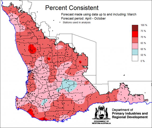
- For April to October the SSF is indicating a 60-80% chance of exceeding median rainfall for parts of the northern grainbelt and along the west coast. Along the southern coast the chance is lower at less than 40%, with neutral (40-60%) chance for the eastern grainbelt. The most probable decile rainfall map indicates decile 8-10 most likely for the northern grainbelt and decile 2-3 in southern parts. Predictive skill is poor to good, 50-75% consistent.
- March rainfall in the SWLD was below average to average. March maximum temperatures were average to above average and minimum temperatures were above average.
Three month outlook for the south-west of Western Australia
Statistical Seasonal Forecasting (SSF)
DPIRD’s Statistical Seasonal Forecast (SSF) system uses historical relationships between global sea surface temperature and sea level pressure with rainfall in south-west Australia to produce forecasts of rainfall for the coming months. Users can click on any station indicated on the map for location-specific forecast information from the Seasonal Climate Information page.
The SSF is indicating less than 40% chance of exceeding median rainfall for the southern grainbelt with neutral conditions (40-60%) elsewhere. A small section of the far northern grainbelt has higher chances at 60-80%. The most probable decile range map indicates decile 2-3 rainfall is most likely for southern parts with decile 4-7 rainfall elsewhere. Predictive skill based on March conditions is poor to good (50-70% consistent). The long-term trend has been for drier autumn and early winter periods for the WA grainbelt and this outlook is consistent with that. Most international climate models have a neutral outlook (that is no preference towards either wetter or drier than normal conditions) for this period.
Bureau of Meteorology seasonal climate outlook
The Bureau of Meteorology’s climate outlooks are generated by a dynamical (physics based) coupled atmosphere-ocean climate model.
The Bureau of Meteorology’s current seasonal outlook indicates generally a 40-50% chance of exceeding median rainfall for April to June 2018 for the SWLD. Predictive skill is mostly moderate to good (55-75% consistent). For the individual month of April, the Bureau is indicating a 30-40% chance of exceeding median rainfall for the SWLD. Given this outlook and the long-term trend for drier autumn and early winter periods, odds favour an average or later-than-average autumn break for parts of southern Australia.
Temperature outlooks for April to June 2018 from the Bureau indicate close to a 50% chance of above normal day-time maxima for the SWLD. Skill is moderate to good at 55-75% consistent. Minimum temperature outlooks indicate a 55-65% chance of above normal night-time minima for the SWLD, with poor to moderate skill at 50-65% consistent.
April to October outlook for South West Land Division
The SSF is indicating for April to October a 60-80% chance of exceeding median rainfall for parts of the northern grainbelt and along the west coast. Along the southern coast the chance is lower at less than 40%, with neutral (40-60%) chance for the eastern grainbelt. The most probable decile rainfall map indicates decile 8-10 most likely for the northern grainbelt and decile 2-3 in southern parts. Predictive skill is poor to good, 50-75% consistent.
Recent climate
Ex-tropical cyclone Joyce brought widespread in late January and ex-tropical cyclone Kelvin brought rainfall in the eastern grainbelt and Esperance region in February. March rainfall in contrast was generally below average in the grainbelt. As a consequence, the forecast soil water map is indicating low soil water for the majority of the grainbelt. Refer to the Seasonal Climate Information page for the 5 April plant available soil water map. March maximum temperatures were average to above average and minimum temperatures were above average.
In March, the atmospheric pressure was slightly higher than normal over the south-west. The Indian Ocean sea surface temperatures northwest and west of WA are slightly cooler.
The La Niña in the tropical Pacific Ocean has ended, and ENSO neutral conditions now prevail. The ENSO Outlook is inactive, meaning there is little sign of El Niño or La Niña developing in the coming months.
The Indian Ocean Dipole (IOD) is currently neutral. IOD events are unable to form between December and April. Four out of six international models suggest a neutral IOD for autumn and early winter, while two show a shift towards a negative IOD during winter. In a negative IOD, sea surface temperatures in the western Indian Ocean are cooler relative to the east, and this pattern typically supports increased cloudiness to Australia's northwest and greater likelihood of tropical cloudbands bringing rainfall to much of Australia. However, model accuracy during autumn is lower than at other times of year, so these outlooks should be used with caution. See the Bureau of Meteorology’s IOD and Pacific Ocean interaction for details.
The Southern Annular Mode (SAM), also known as the Antarctic Oscillation (AAO), describes the north–south movement of the westerly wind belt that circles Antarctica, dominating the middle to higher latitudes of the southern hemisphere. SAM is currently near neutral, but is expected to be positive by mid-April. In a positive SAM event, the belt of strong westerly winds contracts towards Antarctica. During the summer and autumn months (December through to May) the SAM shows an increasing tendency to remain in a positive phase, with westerly winds contracted towards the South Pole. A positive SAM usually means drier conditions for the south-west corner in autumn and winter.
The table below gives a summary of past month and three month south-west Western Australia (SWWA) climate conditions, and can be used as an indication of what is likely to occur in the near future, if climate conditions follow the current pattern.
| Climate indicator | Past month | Past three months |
|---|---|---|
| SWWA rainfall | Below average to average | Above average to average |
| SWWA mean temperature | Above average | Average to above average |
| SWWA atmospheric pressure | Slightly higher | Near normal |
| Indian Ocean sea surface temperature | Cooler | Cooler |
| El Niño/Southern Oscillation (ENSO) | Neutral | La Niña |
| Indian Ocean Dipole (IOD) | Neutral | Neutral |
| Southern Annular Mode (SAM) | Neutral | Positive |

