Summary
The Department of Agriculture and Food, Western Australia’s Statistical Seasonal Forecast (SSF) system is indicating a mixed rainfall outlook for February-April 2017. However rainfall events and major flooding from a tropical low on 9-10 February means that February-April rainfall will be above average regardless of any more rainfall for the Great Southern and Esperance region.
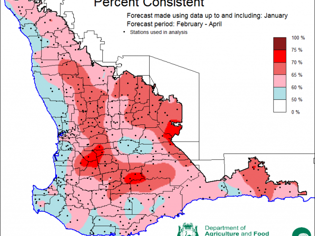
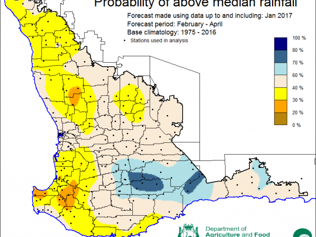
- The SSF is indicating 30-40% chance of exceeding median rainfall for the northern wheatbelt and south-west corner, 60-80% chance of exceeding median rainfall in the Great Southern and 40-60% (neutral chance) elsewhere. Predictive skill based on January conditions is poor to good (50-75% consistent).
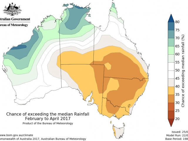
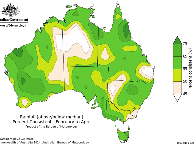
- The Bureau of Meteorology’s current seasonal outlook indicates that SWWA and the southern wheat-belt have equal chances of a wetter or drier February-April 2017, with 45-55% chance of exceeding the median rainfall. For the individual month of February the chances have increased to 60-80% but are lower 25-40% for the month of March. Predictive skill is poor to good (45-75% consistent).
- Temperature outlooks from the Bureau indicate a 45-55% (neutral) chance of above normal day-time maxima and above normal night-time minima across the region for the February-April period (poor to good skill, 50-75% consistent).
- Rainfall in January was average to above average in northern, central and south eastern parts of the South-West Land Division, but average to below average in the southwest. For SWWA, maximum temperatures were average to above average in January, whilst minimum temperatures were below average to average.
Three month outlook for the south-west of Western Australia
Statistical Seasonal Forecasting (SSF)
DAFWA’s Statistical Seasonal Forecast (SSF) system uses historical relationships between global sea surface temperature and sea level pressure with rainfall in south-west Australia to produce forecasts of rainfall for the coming months. Users can click on any station indicated on the map for location-specific forecast information from the Seasonal Climate Information web page.
The SSF forecast for February-April 2017 is indicating 30-40% chance of exceeding median rainfall for the northern wheatbelt and south-west corner, 60-80% chance of exceeding median rainfall in the Great Southern and 40-60% (neutral chance) elsewhere. Predictive skill based on January conditions is poor to good (50-75% consistent). The most probable decile range map indicates decile 2-3 rainfall for February-April for the majority of the wheatbelt and south-west and decile 8-9 for the Great Southern and north and east of the Esperance shire.

Bureau of Meteorology seasonal climate outlook
The Bureau of Meteorology’s climate outlooks are generated by a dynamical (physics based) coupled atmosphere-ocean climate model.
The Bureau of Meteorology’s current seasonal outlook indicates that SWWA and the southern wheat-belt have equal chances of a wetter or drier February-April 2017, with 45-55% chance of exceeding the median rainfall. For the individual month of February the chances have increased to 60-80% but are lower 25-40% for the month of March. Predictive skill for the February-April period is 45-75% consistent, which is considered poor to good.
Temperature outlooks from the Bureau indicate a 45-55% (neutral) chance of above normal day-time maxima and above normal night-time minima across the region for the February-April period (poor to good skill, 50-75% consistent).
Recent climate
Rainfall in January was above average for the majority of the wheatbelt and below average for the south-west corner and parts of the Great Southern area of the wheatbelt. Weekly rainfall totals up to 2 February included 108mm in New Norcia, 130mm in Toodyay East, 171mm in Quairading, 92mm in Hyden and 60mm in Esperance Downs. A second cloudband on 9-10 February associated with a tropical low pressure system moving across the Pilbara and Gascoyne brought large falls and major flooding to areas in the Great Southern. Weekly rainfall totals up to 13 February included 134mm in Beverley, 153mm in Esperance, 181mm in Dumbleyung and 239mm in Ravensthorpe. Some of this rain may still be present in the soil at seeding time, but check DAFWA soil water maps and soil water tool.
January SWWA maximum temperatures were average to above average and minimum temperatures were below average to average.
The El Niño–Southern Oscillation (ENSO) remains neutral, and current predictions are generally for neutral conditions. Indian Ocean sea surface temperatures (SSTs) north of Australia are currently cooler than normal. This is probably due to the recent tropical activity in the Kimberley. The Madden Julian Oscillation is in an active phase but has moved out into the Pacific Ocean away from the Australian region. The Bureau is expecting an average to above average number of tropical cyclones this season and despite having recorded only one tropical cyclone so far, numerous tropical lows have had a impact on the climate of WA over the past months. A continuation of this activity could lead to more rainfall for the northern and eastern wheatbelt if lows move through the region (Olwyn in March 2015 and Elaine in March 1999). For a summary of Pacific and Indian Ocean outlooks, see the Climate Model Summary produced by the Bureau.
The influence of the Indian Ocean Dipole (IOD) on Australian climate is weak during December-April. This is due to the monsoon trough shifting south over the tropical Indian Ocean and changing the overall wind circulation, which in turn prevents an IOD ocean temperature pattern from being able to form. Current outlooks suggest a neutral IOD for the end of autumn.
The Southern Annular Mode (SAM), also known as the Antarctic Oscillation (AAO), describes the north–south movement of the westerly wind belt that circles Antarctica, dominating the middle to higher latitudes of the southern hemisphere. SAM is currently negative but is expected to switch to positive in the middle of February. SAM generally has little influence over SWWA in summer.
In January the atmospheric pressure was below normal over the southwest. A persistent sub-tropical ridge (higher than average pressure across the continent) means there is likely to be fewer low pressure systems than average and passing cold fronts may not extend as far north as usual over the next few months.
The table below gives a summary of past month and three month southwest Western Australia (SWWA) climate conditions, and can be used as an indication of what is likely to occur in the near future, if climate conditions follow the current pattern.
| Climate Indicator | Past month | Past three months |
|---|---|---|
| SWWA rainfall | Above average to average | Mixed |
| SWWA mean temperature | Average | Average |
| SWWA atmospheric pressure | Lower | Lower |
| Indian Ocean sea surface temperature | Cooler | Warmer |
| El Nino/Southern Oscillation (ENSO) | Neutral | Neutral |
| Indian Ocean Dipole (IOD) | Neutral | Neutral |
| Southern Annular Mode (SAM) | Negative | Negative |
Additional information
- Bureau of Meteorology’s severe weather outlook


