Summary
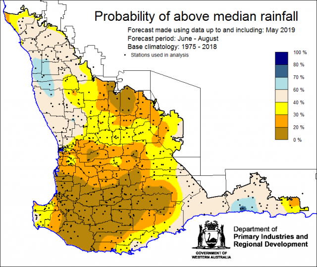
The Department of Primary Industries and Regional Development’s (DPIRD) Statistical Seasonal Forecast (SSF) outlook for winter, June to August 2019 and June to October 2019 is indicating less than 40% chance of exceeding median rainfall for the majority of the grainbelt. Most (80%) of international models expect winter rainfall to be below average over southern WA.
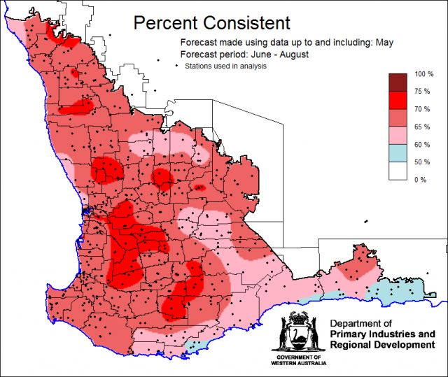
- For winter, June to August 2019 and June to October, the SSF is indicating less than 40% chance of exceeding median rainfall for the central wheatbelt, great southern, south coastal and south west (as classified by the Bureau of Meteorology forecast districts). For the central west and south east coastal districts, SSF is indicating neutral (40-60%) chance of exceeding median rainfall. Most probable decile range is decile 2-3 for the central wheatbelt, great southern, south coastal and south west and decile 4-7 for central west and south east coastal districts. Predictive skill based on May conditions is mostly poor to good (50 -75% consistent).
- The Bureau of Meteorology’s current seasonal outlook is indicating neutral (45-55%) chance of exceeding median rainfall for winter, June to August 2019, for the majority of the grainbelt. Lower chances (30-45%) are for coastal areas. Predictive skill is poor to good (45-75% consistent).
- Temperature outlooks for winter, June to August 2019, from the Bureau indicate 70-80% chance of above average day-time maxima for the SWLD. Skill is poor to moderate at 45-65% consistent. Minimum temperature outlooks indicate 65-80% chance of above average night-time minima for the SWLD, with skill poor to moderate 45-65% consistent. With more cloud-free days and nights expected, there is an increase of frost in susceptible areas.
- May rainfall was very much below average in the SWLD. May maximum temperatures were average to above average and minimum temperatures were very much below average.
- The Indian Ocean is expected to become the dominant influence on Australian climate, with models predicting a positive phase of the Indian Ocean Dipole (IOD) likely to develop in the coming months. The dry years of 2006, 2012 and 2015 (2006 and 2015 were also El Niño years) were all positive IOD years.
Three Month Outlook for the south-west of Western Australia
Statistical Seasonal Forecasting (SSF)
DPIRD’s Statistical Seasonal Forecast (SSF) system uses historical relationships between global sea surface temperature and sea level pressure with rainfall in south-west Australia to produce forecasts of rainfall for the coming months. Users can click on any station indicated on the map for location-specific forecast information from the Seasonal Climate Information web page.
For winter, June to August 2019, the SSF is indicating less than 40% chance of exceeding median rainfall for the central wheatbelt, great southern, south coastal and south west (as classified by the Bureau of Meteorology forecast districts). For the central west and south east coastal districts, SSF is indicating neutral (40-60%) chance of exceeding median rainfall. Most probable decile range is decile 2-3 for the central wheatbelt, great southern, south coastal and south west and decile 4-7 for central west and south east coastal districts. Predictive skill based on May conditions is mostly poor to good (50 -75% consistent).


