Summary
The Department of Primary Industries and Regional Development’s (DPIRD) Statistical Seasonal Forecast (SSF) system is indicating less than 30% chance of exceeding median rainfall for October to December 2018 for the majority of the South West Land Division (SWLD). For Esperance the chance of exceeding median rainfall is greater at 60-80%.
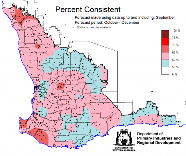
- The SSF is indicating less than 30% chance of exceeding median rainfall for October to December 2018 for the majority of the SWLD. For Esperance, the chance of exceeding median rainfall is greater at 60-80%. The most probable decile range is decile 2-3 for most of the grainbelt and decile 8-9 in Esperance. Predictive skill based on September conditions is mostly poor to good (50-70% consistent).
- The Bureau of Meteorology’s current seasonal outlook is indicating a 30-50% chance of exceeding median rainfall for October to December for the SWLD. Predictive skill is mostly poor to moderate (45-65% consistent).
- Temperature outlooks for October to December 2018, from the Bureau indicate greater than 80% chance of above average day-time maxima for the SWLD. Skill is moderate to good at 65-75% consistent. Minimum temperature outlooks indicate greater than 75% chance of above average night-time minima for the SWLD, with skill mostly good at 55-75% consistent.
- September rainfall was below average for the grainbelt. September maximum temperatures were average to above average and minimum temperatures were generally below average, with a wide spread frost event on 15 September.
Three month outlook for the south-west of Western Australia
Statistical Seasonal Forecasting (SSF)
DPIRD’s SSF system uses historical relationships between global sea surface temperature and sea level pressure with rainfall in south-west Australia to produce forecasts of rainfall for the coming months. Users can click on any station indicated on the map for location-specific forecast information from the Seasonal climate information page.
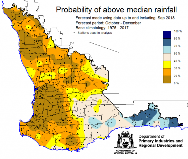
For the next three months, October to December, the SSF is indicating less than 30% chance of exceeding median rainfall for the majority of the SWLD. For Esperance, the chance of exceeding median rainfall is greater at 60-80%. The most probable decile range is decile 2-3 for most of the grainbelt and decile 8-9 for Esperance. Predictive skill based on September conditions is mostly poor to good (50-70% consistent).
Bureau of Meteorology seasonal climate outlook
The Bureau of Meteorology's climate forecast system for monthly and seasonal climate outlooks is called the Australian Community Climate Earth-System Simulator – Seasonal (ACCESS–S). It is a dynamical (physics-based) forecast modelling system and is a collaboration between the Bureau of Meteorology and the UK Meteorological Office.
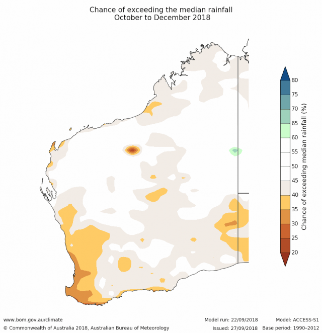
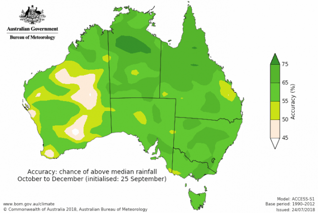
The Bureau of Meteorology’s current seasonal outlook is indicating a 30-50% chance of exceeding median rainfall for October to December for the SWLD. Predictive skill is mostly poor to moderate (45-65% consistent).
Temperature outlooks for October to December 2018, from the Bureau indicate greater than 80% chance of above average day-time maxima for the SWLD. Skill is moderate to good at 65-75% consistent. Minimum temperature outlooks indicate greater than 75% chance of above average night-time minima for the SWLD, with skill poor to good at 50-75% consistent.
Recent climate
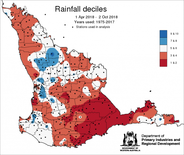
September rainfall was below average for the grainbelt. The last three months’ rainfall (July to September) was generally average to below average. In the July Seasonal Climate Outlook, SSF indicated below median rainfall likely and the Bureau gave a neutral outlook. September maximum temperatures were average to above average and minimum temperatures were generally below average away from the south coast, with a wide spread frost event on 15 September. The rainfall decile map for 1 April to 2 October shows large parts of the grainbelt have received only decile 4 rainfall or lower.
In September the atmospheric pressure was higher than normal over southern Australia, contributing to the below average rainfall. The Indian Ocean sea surface temperatures continue to be cooler than average to Australia's north-west, which is likely acting to suppress rainfall over southern and central Australia.
The Southern Annular Mode (SAM), also known as the Antarctic Oscillation (AAO), describes the north–south movement of the westerly wind belt that circles Antarctica, dominating the middle to higher latitudes of the southern hemisphere. SAM is currently positive. In a positive SAM event, the belt of strong westerly winds contracts towards Antarctica, resulting in weaker than normal westerly winds and higher pressures over southern Australia, restricting the penetration of cold fronts inland. The National Oceanic and Atmospheric Administration (NOAA) suggests that SAM is likely to remain positive until mid-October.
The Indian Ocean Dipole (IOD) is currently neutral. Four of the six international climate models surveyed by the Bureau suggest that index values will remain above positive IOD thresholds into October, so this may be the start of a positive IOD event. It would take several more weeks of values above thresholds for a positive IOD event to be considered established. A positive IOD during spring typically reduces rainfall across much of the eastern two-thirds of Australia and can exacerbate any El Niño-driven rainfall deficiencies. However, IOD events usually decay by the start of summer.See the Bureau of Meteorology’s IOD and Pacific Ocean interaction for details.
The El Niño–Southern Oscillation is currently neutral, but El Niño may develop by late spring. El Niño typically results in below-average spring rainfall for northern and eastern Australia, and warmer days for the southern two-thirds of the country. By summer, the reduced rainfall influence from El Niño contracts to the tropical north.
The table below gives a summary of past month and three month south-west Western Australia climate conditions, and can be used as an indication of what is likely to occur in the near future if climate conditions follow the current pattern.
| Climate indicator | Past month | Past three months |
|---|---|---|
| SWWA Rainfall | Below average | Generally average |
| SWWA Mean Temperature | Average | Average to above |
| SWWA atmospheric pressure | Higher | Near normal |
| Indian Ocean Sea surface temperature | Cooler | Near normal |
| El Niño/Southern Oscillation (ENSO) | Neutral | Neutral |
| Indian Ocean Dipole (IOD) | Neutral | Neutral |
| Southern Annular Mode (SAM) | Positive | Near neutral |

