The extent of waterlogging in south-west Western Australia
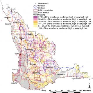
About 3 million hectares of land in the south-west agricultural area has a moderate to very high susceptibility to waterlogging or inundation (Figure 1).
Areas with higher rainfall (mostly greater than 450 mm), low relief and low in the landscape are more susceptible. Shallow duplex soils, particularly with clay subsoil and on slopes less than 10%, are highly susceptible. About 1 million hectares or 5% of the land available to agriculture has a high to very high waterlogging susceptibility.
Estimated losses from waterlogging
The estimated annual loss from waterlogging and inundation in the agricultural areas of Western Australia from 2014/15 to 2018/19 was $46 million. The annual costs vary widely according to the season, and the impacts of waterlogging are regionally restricted and dependent on landscape and soil characteristics.
Annual grain crops are the main crops grown in the area, and these are more affected than pastures.
Factors affecting susceptibility
- climate and seasons
- position in the landscape
- soil characteristics.
Climate
The amount and distribution of rainfall are fundamental factors affecting the expression of waterlogging – seasonal variations explain the large differences in waterlogging between years.
South-western Western Australia has a Mediterranean climate, with cool wet winters and warm to hot dry summers. Annual rainfall varies from about 1000 mm in the south-west corner to about 250 mm at the north-eastern agricultural boundary. The area with annual rainfall above about 450 mm is more likely to experience waterlogging at some period in winter (the wettest months are usually June and July), especially in wetter than average years or following heavy rainfall.
Climate change in South West Western Australia is showing as reduced rainfall – especially in the winter growing season – and higher maximum and minimum temperatures. This change reduces the likelihood of extended periods of waterlogging.
Position in the landscape
Landscape position in decreasing order of waterlogging susceptibility and intensity is: valley floors, footslopes on concave slopes, level plains less than 0.5%, slopes less than 3%, and crests and slopes 3–10%.
For soils susceptible to inundation, landform controls the amount of surface run-on and run-off. The location of seepage areas in uniform coarse-textured soils is controlled by the underlying geology rather than landform.
Soil characteristics
Where water infiltration is higher in the soil A horizon than into the B horizon, water will accumulate in the A horizon, saturate the soil and lead to waterlogging. In the higher rainfall areas, this is common during the wettest periods of winter on shallow duplex soils. Waterlogging can occur for short periods in lower rainfall areas and the effects are usually less damaging.
Where infiltration at the surface is less than incoming rain, water will pond or run-off. This most commonly occurs on clay-surfaced soils and surface-sealing soils.
Soil types and their susceptibility to waterlogging:
-
Uniform coarse-textured soils have high infiltration rates (unless water repellent) and there is no marked change in permeability down the profile. They are only susceptible to waterlogging if the groundwater level is high (i.e. seasonal watertable is within 1 m of the surface). Where a fresh watertable is within 1–2 m of the surface, it can be used productively with perennial species or for farm water supplies.
-
Duplex (permeability contrast) soils have a significantly lower hydraulic conductivity in the B horizon than the overlying A horizon, and this predisposes them to waterlogging. Waterlogging occurs in the more-permeable layer overlying the less-permeable subsoil. Waterlogging may not be visible on the soil surface. Waterlogging is highly variable across duplex soil paddocks, and this is reflected in crop and pasture growth.
The frequency and duration of waterlogging varies considerably depending on the climate, slope, landscape position, permeability of the B horizon, water storage capacity of overlying horizons (a function of depth, gravel percentage, texture and structure) and slope length or distance between surface or subsurface water management structures. -
Cracking clays can be susceptible to inundation on low-lying sites and low (less than 2%) slopes where run-off is slow or non-existent. There is a large variation in infiltration capacity depending on whether the surface cracks are open. Some of these soils have very high infiltration rates with minimal run-off during heavy rainfall but will change to very slow infiltration during heavy rainfall after the cracks close.
If a cracking clay is susceptible to waterlogging, the surface usually has the limiting permeability. If the surface soil has low permeability, then slope and landscape position control the amount of surface ponding or inundation. -
Medium-textured soils can be well drained to poorly drained. The major influencing factors are the permeability of the surface and landscape position. Waterlogging generally occurs from the surface down, although mild waterlogging can occur within the soil profile.
-
Fine-textured soils, particularly those with poor structure or unstable surface, do not allow water to infiltrate readily. In low-lying areas where overland flow is restricted, surface ponding or inundation and saturation of the topsoil often occur. Shallow relief drains can often remove surface ponding.
In areas affected by dryland salinity, plant growth also may be affected by waterlogging. A highly antagonistic interaction between salinity and waterlogging affects the growth of most crop and pasture plants.
| Susceptibility to waterlogging | Profile hydrology group | |||
|---|---|---|---|---|
| Uniform coarse- textured soils | Duplex soils | Cracking clays | Medium- and fine-textured soils | |
| General susceptibility | Usually not susceptible | >95% are susceptible under moderate to high rainfall | Variable; depends on site characteristics and condition of surface | Variable — some are very susceptible because of poor internal drainage; often in low-lying areas susceptible to inundation |
| Requirements to be susceptible | Shallow watertable or seepage area (hillside seep) | Susceptible unless slope is >5%, or rainfall <300 mm | Low-lying position, slope <1–2% and poor surface condition | Low slopes <3%, and low surface infiltration or a slowly permeable layer in the profile |
| Contributing factors | Shallow watertable, seepage zone | Slowly permeable subsoil, slope <1%, shallow topsoil, run-on, shallow seepage, sandy topsoils which assist infiltration and inhibit evaporation | Run-on, microrelief (e.g. internal drainage to ‘crabholes’) | Run-on, seepage from upslope, groundwater discharge |
Diagnosing waterlogging
Steps to diagnose waterlogging:
- Observe the signs of waterlogging in soils and plants.
- Note the soil type and landscape position.
- Check soil in the root zone for water content.
- Note yield changes against marked areas.
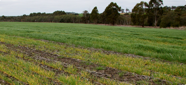
The best way to identify waterlogged areas is by inspecting them. In winter, if water is present at the surface (i.e. glistening in little depressions), the area is likely to be waterlogged. If waterlogging is suspected and water is not on the surface, dig a few holes down to about 30 cm and see if water flows into them; if it does, the soil is waterlogged.
See the diagnosing waterlogging page for more information on measuring waterlogging.
Managing waterlogging
The best management depends on the severity, landscape position and land use (type of crops or pastures). Management can include any of these options:
- No treatment, just avoid waterlogged areas when seeding, spraying, harvesting. This is only recommended for small areas.
- Sow crops on more-susceptible areas first.
- Alter nitrogen management to suit the waterlogged situation.
- Change the land use (use different crops or pasture).
- Install shallow surface drainage on waterlogged or inundated areas.
- Install surface water drainage upslope to prevent waterlogging occurring or reducing the period of waterlogging.
- Install raised beds with shallow surface drainage on highly susceptible flats.
See the managing waterlogging in crops and pastures page for more information.


