Why we investigated Myalup–Wellington soil and land capability
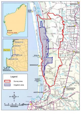
We conducted a broad-scale soil survey in the Myalup and Binningup areas to identify land suitable for expanding irrigated agriculture. The survey covered 38 000 hectares just east of Myalup, between Johnston Road to the north and the Brunswick River to the south (Figure 1).
In the survey area, sandy soils of the Spearwood and Karrakatta series are highly sought-after for irrigated horticulture because their good drainage and workability means they can be cropped year round. They also have better water- and nutrient-holding capacities than many of the surrounding soils on the Swan Coastal Plain.
What we did
We did a desktop analysis and visited field sites to identify soil characteristics. The assessment included:
- describing soil profiles at 140 new sites
- analysing the chemical and physical properties of 80 soil samples
- updating existing soil mapping
- characterising the major soil-landscape types as land management units (LMUs), which can be used as a guide to how an area of land will react and produce under certain management
- creating land capability maps for irrigated horticulture covering 20 000 hectares of land potentially available for development.
What we found
- The most significant area for expansion is 3500 hectares of the Myalup pine plantations that has moderate to high capability for irrigated horticulture.
- There are limited opportunities for expanding horticulture within the current irrigation area.
- The main soil types suitable for irrigated horticulture in this area are yellow deep sands, and pale deep sands with yellow sandy subsoils, belonging to the Karrakatta series.
More information
For more information contact David Rowe (details below).
Groundwater chemistry and salinity processes in the Myalup irrigation area
We investigated the groundwater processes causing changes in salinity in the Myalup irrigation area, as part of the broader Myalup–Wellington project. Salinity has been increasing in the aquifer and this may be a result of evaporation, recycling of irrigation return water, applied fertiliser or saltwater intrusion.
What we did
We analysed licensee water quality data from nearly 200 sites – collected since 2009 – plus groundwater samples from an additional 61 targeted sites with more comprehensive chemistry data to identify the sources of salinity and trends over time.
We analysed changes in water quality through time from all licensee bores within areas of irrigated agriculture to determine the rate and scale of salinity increases, and identify the likely causes of the increases. We used groundwater licensee information at 140 sites to look for changes in salinity, sulfate, chloride and nutrient levels since 2007.
What we found
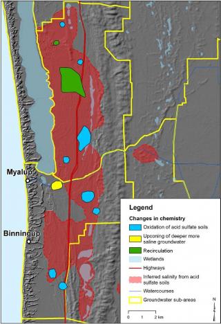
- The licensee and groundwater data showed there were multiple geochemical processes contributing to the increased salinity along the groundwater flow path in the Myalup aquifer (Figure 2).
- Only 30 of the 140 sites from land with irrigated agriculture showed increased salinity, while six sites showed decreased salinity.
- Pyrite oxidation, the source of sulfate, was the main cause of increased salinity across most of the agricultural area.
- Recirculation, upconing and intrusion of saline groundwater were other processes contributing to increasing salinity in the groundwater.
- Fertiliser application was not a major source of salinity for the Myalup area.
The Myalup–Wellington project is supported by the State Government's Royalties for Regions program.
More information
For more information contact Adam Lillicrap (details below).
Download Groundwater chemistry and salinity processes in the Myalup region - RMTR 404. Note – this is a large PDF (22.2MB) and could be slow to download.


