Summary
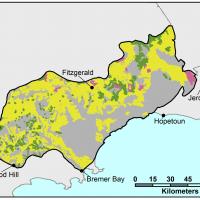
| Occurrence | Stirlings to Ravensthorpe (6%) |
|---|---|
| Soil Groups of Western Australia (WA) | 301 Deep Sandy Gravels to 80 cm + (Forest gravel) 302 Duplex Sandy Gravels - gravel to 30–80 centimetres (cm) (Gairdner gravels) 303 Loamy Gravel (Jarrah Gravel) |
| Also known as | Gairdner gravelly duplex, Jarrah gravel, Forest gravel soil |
| Australian soil classifications | 301 - Ferric or Ferric-Petroferric Tenosol, Ferric Kandosol, Ferric Chromosol 302 - Ferric Chromosol, Ferric Sodosol, Ferric Kandosol 303 - Ferric Kandosol, Ferric Chromosol, Ferric Dermosol |
Distinguishing features
Topsoil
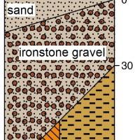
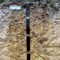
- Yellow, brown or grey sandy soils to 30cm.
- Acidic to neutral pH.
- Gravel increasing gravel with depth.
Subsoil
- Gravels dominant feature (>20% by weight) and can be unconsolidated (pea, buckshot) or cemented.(conglomerate).
- Gravels overly semi permeable clays or clay loams or reticulite between 30–80cm depth.
Constraints
The following data has been derived from actual site samples taken. These results are recorded in this Excel spreadsheet.
| Rating | Limitation |
|---|---|
| Not applicable (n/a) | No constraints identified |
| Minor | Minor constraint - reduces crop yields in some years |
| Major | Major constraint - reduces crop yields in most years |
| Severe | Severe constraint - will always reduce crop yields |
| Soil Group of WA | 302 Duplex Sandy Gravels* | 302 Duplex Sandy Gravels* |
| Constraints | Topsoil | Subsoil |
| Minor | n/a | |
| n/a | n/a | |
| Sodicity and alkalinity | n/a | Major |
| n/a | n/a | |
| Severe | Severe | |
| Aggregate stability | n/a | Major |
| n/a | n/a | |
| n/a | n/a | |
| Major | n/a | |
| Low plant available water | Major | Major |
| Water-logging (seasonal) | n/a | n/a |
| Wind erosion (seasonal) | Minor | n/a |
| Water erosion (seasonal) | n/a | n/a |
*Note - Data derived from site identifications (ID's).
- Soil Group of WA - 302 Duplex sandy gravels site ID includes: JSI 1145.
Further information
McArthur, WM (2004) Reference Soils of South-western Australia (Reprint). Department of Agriculture, Western Australia.
Moore, G (2004) Soil Guide: A Handbook for Understanding and Managing Agricultural Soils. Bulletin 4343. Department of Agriculture, Western Australia.
Overheu, TD (1995) Soil Information Sheets for Ravensthorpe and Part of the Jerramungup Agricultural Areas. Department of Agriculture Western Australia and Landcare Western Australia.
Stoneman, TC (1990) An Introduction to the Soils of the Jerramungup Advisory District. Western Australian Department of Agriculture. Bulletin 4201.
Schoknecht, N and Pathan, S (2013) Soil Groups of Western Australia. Resource Management Technical Report 380. Department of Agriculture and Food, Western Australia.


