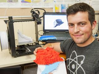
The use of cutting-edge 3D printing has transformed complex land and water data into a hand-held plastic model, to help provide a clearer illustration of the agricultural potential in the State’s north.
Department of Agriculture and Food research officer Nick Wright combined his interest in hydrogeology and digital technology to model and 3D print a vast, remote area of the west Kimberley.
The model depicts of the top three hydrogeological layers of the earth’s surface across 3.5 million hectares of the La Grange groundwater allocation area, south of Broome.
The work is part of the La Grange Agricultural Opportunities project, made possible by Royalties for Regions, to expand irrigated agricultural production in the Kimberley.
Mr Wright printed the model over a period of a month from the comfort of his South Perth office at a cost of just $40, not including the cost of the $2000 machine.
The small printer uses a fine strand of plastic to print layer-upon-layer to build the model over a period of hours.
The La Grange model started with topographical data from the NASA shuttle radar topography mission, freely available on the internet, to compile the top, red layer of the model of unsaturated Broome sandstone.
The department’s ground water monitoring data was used to create the light blue segment which represents the fresh water aquifer for the area.
The white layer shows the underlying impenetrable Jarlemai Siltstone, compiled from an aerial electromagnetic survey completed by the department in 2013.
The dark blue layer represents the ocean, which sits on top of another segment that shows the geology saturated with ocean water. This layer penetrates underground for about 10 kilometres inland, affecting the saline content of groundwater along the coast.
Mr Wright said he had great confidence in the usefulness of the scale model as a demonstration and communication tool.
“Satellite imagery in conjunction with basic groundwater simulations were also used in a novel approach to identify 114 ground water dependent ecosystems across the area that provide additional data points to increase the accuracy of the groundwater model,” he said.
The top red layer of the model also includes 27 raised dots to pin-point proposed groundwater monitoring bores.
The model was recently shown to pastoralists and traditional landholders in the Kimberley and received positive feedback.
“Straight away they could see what we’re dealing with, as the model provided a nice, visual way to explain the irrigation opportunities and constraints of the area,” Mr Wright said.
“The data sets that went into creating this model will also assist scientists and policy makers with water management and allocation decisions, as well as aid a range of other potential applications.”
The department has also used the 3D printer to assist the operators of the Muchea saleyards with water runoff management.
Mr Wright said that with innovative thinking, 3D printing could be applied in a myriad of ways across the department.
“After a thorough online search we were unable to find any hydrological applications of 3D printing so we really started from scratch in developing this approach,” he said.
“There are a lot of directions that you could take this technology. Once people learn what is possible with 3D printing it will become more useful in a range of areas.”

Media contacts: Jodie Thomson/Lisa Bertram, media liaison +61 (0)8 9368 3937
