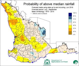
Below average rainfall has been forecast for the next three months across the grainbelt, with the exception of two north eastern shires, for which above average rainfall is predicted.
According to the Department of Agriculture and Food’s latest Statistical Seasonal Forecasting (SSF) model, rainfall from July to September is most likely to be drier than average over much of the grainbelt and South West.
However, the shires of Westonia and Yilgarn have increased chances of exceeding median rainfall for this period.
The predictive skill of the forecast at this time of year varies across the region, with highest skill over the northern and north-eastern grainbelt, as well as the South West. The central grainbelt has a lower skill.
Research officer Meredith Guthrie said the latest SSF was influenced by higher than normal mean sea level pressure over the south west of the State.
“The most probable rainfall range for July to September in the northern and central grainbelt is decile 2-3, for the southern grainbelt decile 4-7 and decile 8-10 for the eastern grainbelt, including the shires of Nungarin, Mukinbudin, Westonia and Yilgarn,” Dr Guthrie said.
“The outlook for July to October continues this pattern, with reduced chances of above median rainfall for most of the grainbelt and a wetter outlook for eastern parts of the region,” Dr Guthrie said.
With the El Nino Southern Oscillation returning to a neutral state, there is now a 50-50 chance of a La Nina developing.
“The models indicate that if a La Nina did develop it would be weak in strength and will not last for long,” Dr Guthrie said.
The Southern Annular Model, also known as the Antarctic Oscillation, is currently positive, which is expected to restrict the penetration of cold fronts inland and cause generally below average rainfall.
The Indian Ocean Dipole (IOD) is currently negative and this generally brings more rainfall over eastern and southern Australia in the form of northwest cloud bands.
“However, recent analysis from the Bureau of Meteorology indicates that only average rainfall is likely for the south west of the State in a negative phase of the IOD,” Ms Guthrie said.
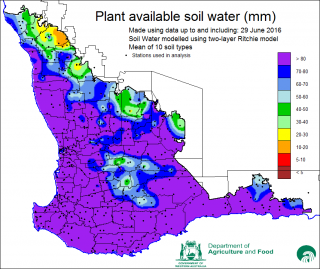
The Soil Water map from 29 June indicates very high levels of plant available water across most of the grainbelt, with some soils at saturation levels.
Department research officer David Ferris said the drier forecast would be a welcome change in areas where saturated soils have restricted vehicle access to paddocks to apply in-crop herbicides and top-up fertiliser inputs.
“Overall, the grainbelt is still on track to produce a bumper crop, in spite of the generally below average rainfall outlook, as cumulative rainfall to date and projected decile finishes will still achieve above average total growing season rainfall in most regions,” he said.
“Currently there are issues with waterlogging and vehicle access to paddocks with saturated soils in central, Great Southern and South Coastal areas.
“Drier conditions over the next three months will help to improve the traffic-ability of heavy soils, reduce water logging and nutrient leaching and enable the application of in-crop herbicides.”

Media contacts: Jodie Thomson/Megan Broad, media liaison +61 (0)8 9368 3937

