Summary
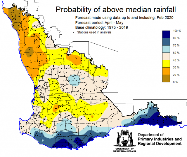
The Department of Primary Industries and Regional Development’s (DPIRD) Statistical Seasonal Forecast (SSF) outlook for April to May 2020 is indicating less than 40% probability of above median rainfall in the north and greater than 70% chance in the south of the South West Land Division (SWLD). We are currently recalibrating the SSF with new data from NOAA, so can only give the next two month outlook at this time.
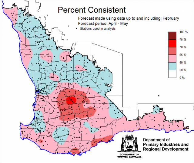
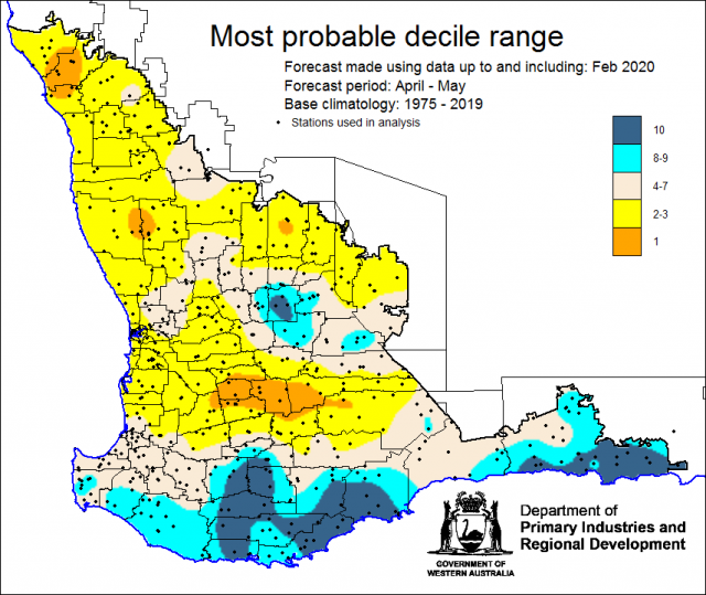
- For April to May 2020, the SSF is indicating less than 40% chance of exceeding median rainfall for parts of the Central West, Central Wheatbelt and Great Southern Districts. Higher chances (greater than 60%) for parts of the South West, Great Southern, South Coastal and South East Coastal Districts. Neutral chances (40-60%) for other areas of the South West Land Division. The most probable rainfall decile map indicates decile 2-3 for parts of the Central West, Central Wheatbelt and Great Southern Districts and decile 8-10 for parts of the Great Southern, South Coastal and South East Coastal. Predictive skill based on February conditions is poor to good (50 -75% consistent).
- The Bureau of Meteorology’s current seasonal outlook is indicating 65-75% chance of exceeding median rainfall for April to June 2020. Predictive skill is poor to good (55-75% consistent). The longer-term outlook for May to July has lower chances at 45-65% chance, with the higher chances for northern and eastern grainbelt. Predictive skill is 55-65% consistent. The rainfall outlook suggests the autumn break for southern cropping regions may occur closer to its average time this year.
- Other models are indicating a neutral rainfall outlook for the next three months
- Temperature outlooks for April to June 2020, from the Bureau indicate a 35-55% chance of above average day-time maxima (skill 55-100%) and 70-80% chance of above average night-time minima (skill 45-65%) for the SWLD.
- March rainfall was average to abover average for the SWLD. March maximum temperatures were average to above average and minimum temperatures were very much above average.
- A stronger north to south sea surface temperature gradient in the eastern Indian Ocean combined, with south-westerly winds, increases the likelihood of northwest cloud-bands and hence increasing the chance of wetter than average conditions across central and southern Australia for the next three months.
Three Month Outlook for the south-west of Western Australia
Statistical Seasonal Forecasting (SSF)
DPIRD’s Statistical Seasonal Forecast (SSF) system uses historical relationships between global sea surface temperature and sea level pressure with rainfall in south-west Australia to produce forecasts of rainfall for the coming months. Users can click on any station indicated on the map for location-specific forecast information from the Seasonal Climate Information web page.
For April to May 2020, the SSF is indicating less than 40% chance of exceeding median rainfall for parts of the Central West, Central Wheatbelt and Great Southern Districts. Higher chances (greater than 60%) for parts of the South West, Great Southern, South Coastal and South East Coastal Districts. Neutral chances (40-60%) for other areas of the South West Land Division. The most probable rainfall decile map indicates decile 2-3 for parts of the Central West, Central Wheatbelt and Great Southern Districts and decile 8-10 for parts of the Great Southern, South Coastal and South East Coastal. Predictive skill based on February conditions is poor to good (50 -75% consistent).


