Summary
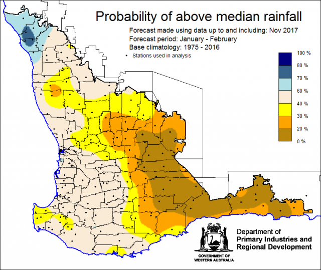
The Department of Primary Industries and Regional Development’s (DPIRD) Statistical Seasonal Forecast (SSF) system is indicating less than a 40% chance of exceeding median rainfall for January 2018 to February 2018 for the majority of the wheatbelt.
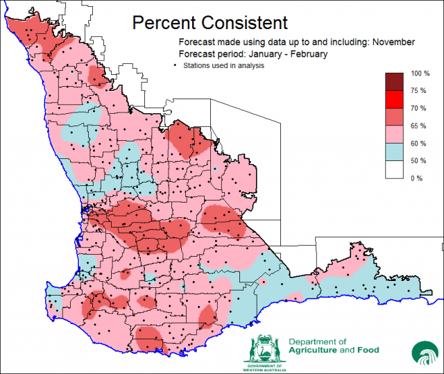
- This month, the SSF covers only January and February and is based on climate conditions in November 2017. Most of the eastern and south-eastern eastern agricultural regions have less than a 40% chance of exceeding median rain for the period. The most probable rainfall decile range is decile 2-3. The far northern agricultural region has higher chances (60-70%) of exceeding median rainfall, with decile 8-10 rainfall being most likely. Elsewhere the chances are close to 50%, with decile 4-7 rainfall being most likely. Predictive skill based on November conditions is poor to good (50-70% consistent).
- The Bureau of Meteorology’s current seasonal outlook indicates a 60-80% chance of exceeding median rainfall for January to March 2018 for the South West Land Division (SWLD). This wetter outlook is likely influenced by recent increases in sea surface temperatures to the north-west of Western Australia. Predictive skill is poor to good (45-75% consistent).
- Temperature outlooks for January to March 2018 from the Bureau indicate a 60-80% chance of above normal day-time maxima for the south-west region in particular. Other parts of the SWLD have near neutral chances. Skill is moderate to good at 55-75% consistent. Minimum temperature outlooks indicate a 60-80% chance of above normal night-time minima for most the SWLD, with poor to moderate skill at 45-65% consistent.
- December rainfall in the SWLD was above average along the coast, average in the central wheatbelt and below above in the eastern wheatbelt. December maximum and minimum temperatures were near average or above average.
Three month outlook for the south-west of Western Australia
Statistical Seasonal Forecasting (SSF)
DPIRD’s SSF system uses historical relationships between global sea surface temperature and sea level pressure with rainfall in south-west Australia to produce forecasts of rainfall for the coming months. Users can click on any station indicated on the map for location-specific forecast information from the Seasonal Climate Information page.
Due to technical difficulties, SSF outlook is for January to February 2018 and does not include March. The outlook is based on climate conditions in November 2017. The SSF is indicating 60-70% chance of exceeding median rainfall for the far northern agricultural region. In contrast, there is less than 40% chance for eastern and south-eastern agricultural regions. Neutral (40-60%) chances apply elsewhere. The most probable decile range map indicates decile 2-3 rainfall is most likely for the eastern and south-eastern agricultural regions, with decile 8-10 rainfall likely for the far northern wheatbelt and decile 4-7 elsewhere. Predictive skill based on November conditions is poor to good (50-70% consistent).


