Summary
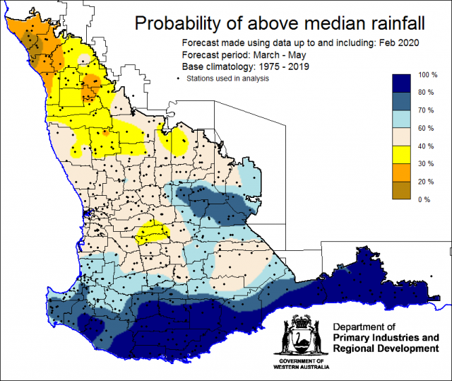
The Department of Primary Industries and Regional Development’s (DPIRD) Statistical Seasonal Forecast (SSF) outlook for autumn, March to May 2020 is indicating less than 40% probability of above median rainfall in the north and greater than 60% chance in the south of the South West Land Division (SWLD).
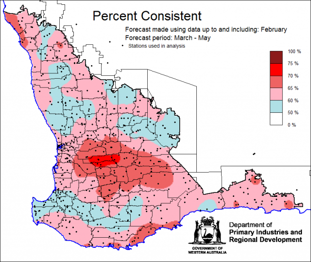
- For autumn, March to May 2020, the SSF is indicating less than 40% chance of exceeding median rainfall for parts of the Central West District with higher chances (greater than 60%) for parts of the South West, Great Southern, South Coastal and South East Coastal Districts. Neutral chances (40-60%) for other areas of the South West Land Division. The most probable rainfall decile map indicates decile 2-3 for parts of the Central West and Central Wheatbelt Districts and decile 8-10 for parts of the Great Southern, South Coastal and South East Coastal. Predictive skill based on February conditions is poor to good (50 -75% consistent).
- The Bureau of Meteorology’s current seasonal outlook is indicating 45-75% chance of exceeding median rainfall for autumn, March to May 2020. Predictive skill is poor to good (50-75% consistent). The longer-term outlook for April to June is also 45-75% chance, with the higher chances for eastern grainbelt.
- Temperature outlooks for autumn, March to May 2020, from the Bureau indicate a 35-55% chance of above average day-time maxima (skill 45-65%) and 75-80% chance of above average night-time minima (skill 50-65%) for the SWLD.
- February rainfall was above average for the majority of the SWLD due to ex-tropical cyclone Damien and a period of sustained thunderstorns late in the month.February maximum temperatures were average to above average and minimum temperatures were very much above average.
- Indian Ocean sea surface temperatures (SST) off the WA coastline have been warmer than average. Warmer waters surrounding northern Australia are also likely, which would typically increase the chance of wetter conditions in southern and eastern Australia.
Three Month Outlook for the south-west of Western Australia
Statistical Seasonal Forecasting (SSF)
DPIRD’s Statistical Seasonal Forecast (SSF) system uses historical relationships between global sea surface temperature and sea level pressure with rainfall in south-west Australia to produce forecasts of rainfall for the coming months. Users can click on any station indicated on the map for location-specific forecast information from the Seasonal Climate Information web page.
For autumn, March to May 2020, the SSF is indicating less than 40% chance of exceeding median rainfall for parts of the Central West District with higher chances (greater than 60%) for parts of the South West, Great Southern, South Coastal and South East Coastal Districts. Neutral chances (40-60%) for other areas of the South West Land Division. The most probable rainfall decile map indicates decile 2-3 for parts of the Central West and Central Wheatbelt Districts and decile 8-10 for parts of the Great Southern, South Coastal and South East Coastal. Predictive skill based on February conditions is poor to good (50 -75% consistent).


