The rangelands of Western Australia
Western Australian (WA) rangelands cover about 2.2 million square kilometres (87% of WA) and are contained wihtin 20 IBRA (Interim Biogeographic Regionalisation of Australia) bioregions. Climates range from tropical monsoonal to arid temperate.
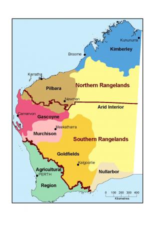
The WA rangelands can be considered as 2 main types – the northern grasslands and the southern shrublands, with distinct regions (Figure 1)
Information on these plants can assist pastoral lessees and station managers to assess pasture condition and trend, and improve grazing management.
This information is from well-respected publications, and observations, monitoring and trials by the Department of Primary Industries and Regional Development.
Common plants by subregion
Declared plants in the rangelands
See Declared plants in the rangeland regions of Western Australia
References
Mitchell, AA & Wilcox, DG 1994, Arid shrubland plants of Western Australia, revised edition, Department of Agriculture, Western Australia, Perth.
Petheram, RJ & Kok, B 2003, Plants of the Kimberley region of Western Australia, revised edition, University of Western Australia Press, Perth.
For more information
In the Kimberley, contact Matt Fletcher or Kath Ryan
In the Pilbara or Gascoyne, contact Damian Priest or Joshua Foster
In the Goldfields and southern rangelands, contact Joshua Foster, Wayne Fletcher or PJ Waddell


