Introduction
These Southern rangelands pasture condition and management guides are based on the accumulated work of rangeland colleagues past and present that has been conducted over more than half a century, published in nine rangeland surveys, and spans the majority of the Western Australian shrublands. Additional data and reports from the Western Australian Rangeland Monitoring System (WARMS) at the regional and landscape scale have been used to expand, update and improve on surveyed information.
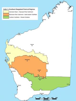
The southern rangeland pasture condition guides are relevant to about 815,000 square kilometres of the rangelands of Western Australia (Figure 1), of which the major land uses are: pastoral lease (60%); unallocated Crown land (24%); and conservation estate (12%) in 2020. The area has been the subject of nine inventory and condition surveys, mainly undertaken by the Department of Primary Industries and Regional Development or its previous constituent departments. In compiling these guides, 402 of the full range of land systems described in rangeland surveys and 272 habitat (or vegetation) types have been considered.
This information is for pastoralists, resource managers, government departments and others with an interest in the productivity and sustainability of pastoral land in the Gascoyne, Murchison, Goldfields and Nullarbor, Western Australia.
Pastoralists can use these guides to identify pasture condition for each pasture type, and then develop a management plan to maintain or achieve good condition pastures.
What is pasture condition?
Pasture condition describes the state of a given pasture relative to the optimal condition in a well-managed pastoral system on that site (region, landscape position, soil, climate, vegetation).
The density and diversity of palatable species (often called desirables or decreasers) largely determines pasture condition in the rangelands. Each pasture type represents a broad group of similar vegetation associations which have similar management requirements for pastoralism.
Pasture condition is rated as good, fair or poor, depending on how close the current condition is to the optimal condition. What you expect to see at a site in good, fair or poor condition depends on the pasture type that occurs there. Identify the pasture type first.
A note about species identification
All of the guides use scientific names for the species found in the listed pasture types. Scientific names are usually in the form of Genus species. For example Eragrostis eriopoda. There is only one current scientific name for a plant – which you can check on the Taxonomy section of the Australian Plant Census web site or in FloraBase – but there may be many common names, and some common names can refer to several spcies. For instance, Eragrostis eriopoda has the common names of: woollybutt; naked woollybutt; neverfail; woollybutt grass; naked woollybutt grass; neverfail grass.
The genus always has a capital; the species is always lower case; common names are lower case unless they have a proper noun in the name, such as Shark Bay poverty bush.
We always recommend using scientific names if possible, or at least confirming the scientific name of the common name you are using.
Pasture condition an.d pastoral assessment
In response to concern about the overall condition of the WA rangelands, the State Government has endorsed a contemporary risk-based system for assessing pastoral lands. This system is described in the Framework for Sustainable Pastoral Management – Revised edition (the Framework), with additional information in the Framework for sustainable pastoral management - Land condition version.
Under the Framework, DPIRD is developing quantitative regional land condition standards to make station-level assessments consistent and objective for land condition and management effectiveness.
The standards will be based on the proportion of key pastures in good, fair or poor condition. The Southern rangelands pasture condition and management guides will help managers identify the condition status of 23 broad pasture groups occurring in the southern rangelands.
DPIRD assesses pasture condition based on the density and gorund cover of indicator species for that pasture.
Assessments of pastoral condition (pastures and soil) are used by the Department of Planning, Land and Heritage and the Department of Primary Industries and Regional Development to check compliance with the terms of the lease, and compliance with the Soil and Land Conservation Act 1945.
Identifying pasture types
Pastures in the southern rangelands are often referred to as 'shrublands', and the northern rangelands pastures are usually referred to as 'grasslands'.
Pastures in the southern rangelands are in 3 major groups:
- chenopod dominated pasture (10 pasture types)
- other shrub dominated pastures (8 pasture types)
- grass dominated pastures (5 pasture types).
Most of the southern rangelands supports chenopod pastures and other shrub pastures.
Grass pastures are locally important: buffel grasses have changed riparian landscapes in parts of the Gascoyne and Murchison and may change Goldfields-Nullarbor landscapes in the future. Broadscale ribbon grass pastures are no longer present in the Carnarvon area due to historical degradation and are not included.
Breakaway footslope pastures have been described together with mixed chenopod shrub plain pastures; riverine mixed shrub and river frontage have been described together as riparian association pastures.
For each of the 23 most common pasture types in the southern rangelands, the guides describe:
- pastoral potential
- management information
- good, fair and poor condition
- vegetation structure and composition
- commonly associated plants grouped into desirable, intermediate and undesirable species.
The 23 pastures are listed and linked to their detailed pages in Southern rangelands pasture condition and management guides.
Soil type and position in the landscape, along with vegetation, are used to distinguish between the common pasture groups. Projected foliar cover (PFC), where known, is used to describe the extent of perennial shrub vegetation and hummock grass (spinifex) cover, as a percentage of groundcover.
Pastoral value
This guide uses six categories of pastoral value or potential, based on estimated carrying capacity in either dry sheep equivalents (DSE), animal equivalents (AE) or cattle units (CU) (Table 1).
Please note:
Potential carrying capacities in the southern rangelands have traditionally been expressed in DSEs. Over recent decades, cattle have been replacing sheep in the southern rangelands, and the carrying capacities in cattle units were based on 1 CU = 7 DSE. However, more recent research based on the energy requirements for sheep and cattle mean that DPIRD has adopted a new cattle standard, the animal equivalent (AE), which is likely to be an Australian national standard.
An AE is based on a 450 kg Bos taurus steer 2.25 years of age, walking 7 kilometres each day, with an intake of 73 MJ ME/day. Based on energy requirements, 1 AE = 8.4 DSE
A DSE refers to a 45 kilogram liveweight Merino wether with zero weight change, no wool growth additional to that included in maintenance, and walking 7 km/day, with an intake of 8.7 MJ ME/day. This definition is used in the northern and the southern rangelands.
| Pastoral potential | Carrying capacity ha/DSE | Carrying capacity ha/CU | Carrying capacity ha/AE |
|---|---|---|---|
| Very high | <5 | ≤35 | ≤42 |
| High | 5.1–9.9 | 36–69 | 43–83 |
| Moderately high | 10–14.9 | 70–104 | 84–125 |
| Moderate | 15–19.9 | 105–139 | 126–167 |
| Low | 20–29.9 | 140–209 | 168–251 |
| Very low | ≥30 | ≥210 | ≥252 |
As a general rule, fair condition pastures are 50–70% as productive as good condition pastures, and poor condition pastures are less than half as productive as good condition pastures. These values are a guide only, and may vary considerably in some situations.
The actual grazing value and appropriate stocking of particular pastures at any time varies with seasonal conditions, fire history, perennial pasture condition and degree of recent use. The aim of good grazing management is to match grazing pressure with available pasture production as closely as possible. Fixed year-round stocking rates result in either under-use or over-use at most times and are largely inappropriate for arid zone pastures.
Carrying capacities provided by DPIRD are a guide to land capability and productive potential and are not intended to be rigidly applied by managers or used as the sole basis for legislative controls.
Pasture condition decline
Condition declines when any of the following changes occur:
- desirable species are replaced by less-desirable species
- reduced plant cover increases the proportion of bare soil
- erosion accelerates
- production of palatable perennial species declines
- any combination of these changes.
Fertile patches and tree-based clumps
Arid landscapes are generally resource-poor, and commonly consist of ‘fertile patches’ within greater resource-poor areas or ‘inter-patches’ (Tongway 1994). Patch-interpatch interactions for water and nutrient capture are important for the resilience and sustainability of arid zone systems.
Tree-based groves, bush clumps and wanderrie banks act as fertile patches. Tree-based groves and shrub thickets can be generated by birds dropping seed and dung from ‘perch’ trees, large shrubs, around rock outcrops and termite mounds.
Fertile patches, and particularly tree-based groves, are valuable indicators of landscape health. Monitoring sites in these preferentially grazed habitats provide an effective way to monitor pasture condition.
The value of fertile patches
Fertile patches:
- capture, recycle and use scarce resources (water and nutrients)
- support greater species density and diversity than the surrounding landscape
- are a source for plant re-establishment after extended dry periods or disturbance
- provide forage during dry periods.
Branch and leaf litter accretes around tree and shrub bases within groves and this slow or blocks wind and water flow, resulting in material (e.g. leaf litter, seeds, animal scats, general debris) being deposited within and immediately upslope of the grove or clump.
This deposited material enriches soil with nutrients, particularly nitrogen, increases microbial activity and contributes to greater soil moisture (Garner and Steinberger 1988), and creates improved conditions for germination and establishment. This improves landscape and habitat structural complexity; biomass productivity; connectivity of habitat for fauna; places of refuge in extended dry periods; and is a valuable seed source for recovery after periods of environmental stress.
Grazing damage and fertile patches
Fertile patches are particularly attractive to grazers and browsers, and susceptible to overgrazing. Repeated browsing of foliage and bark, breaking of limbs and eventually the central crown, can kill individual trees.
Heavy browsing of tree groves and tree-based clumps by large herbivores can result in:
- high browse lines, eliminating the browse source for smaller herbivores
- loss of shrubs from around tree-based groves and within groves resulting in:
- reduced carrying capacity
- reduced species composition
- loss of habitat
- loss of shade for livestock and other animals
- changed surface water flow with either accelerated flows causing erosion, which strips away precious resources, or restricted flows resulting in droughted plants.
Projected foliar cover
Projected foliar cover (PFC) used in the guides to describe the extent of perennial shrub vegetation and hummock grass (spinifex), as a percentage of groundcover. The ranges for each category term are shown in Table 2 (adapted from Curry, Payne and Wilcox 1983).
| Term | Range (%) |
|---|---|
| Isolated | 0–2.5 |
| Very scattered | 2.5–10 |
| Scattered | 10–20 |
| Moderately close | 20–30 |
| Close | 30–50 |
| Closed | >50 |
States and transitions – are changes in pasture condition and composition reversible?
Change from one state to another is referred to as a transition. These new states can be relatively resistant to change, creating essentially permanently altered pastures that may have a lower (or higher) grazing value than the original pasture. Changing management can influence the pasture species and sometimes the change in state.
When desirable perennial species are lost through adverse conditions or heavy grazing, they are commonly replaced by less palatable perennial or annual species and form a new stable state.
Experience in the Pilbara and elsewhere shows that it is not always possible to improve degraded pasture to its original, more productive condition. Changes in the composition of a pasture as a consequence of various pressures (grazing history, fire and drought) may not be directly reversible or even desirable. If the change is to a new stable state, this is called a transition.
There are some conditions in which grazing value may be improved by a transition. An example is where degraded pasture is colonised by buffel grass in association with desirable native grasses: this change is likely to be more productive, although it will require a change of management.
Assessing pasture condition
When is the best time to assess pasture condition?
Pasture condition can be assessed at any time of the year because it depends on the species present and their density rather than on bulk (biomass). However, it is easier to identify species after the season of greates rainfall and pasture growth. In the dry season, fire or heavy grazing can make identification difficult.
How often should pasture condition assessments be done?
The frequency of assessments depends on how quickly the pasture condition is changing. Yearly assessments can show a trend that might be slow or fast to be obvious. Climatic conditions are very variable in the Pilbara, so assessments over 10 or more years might be needed to see reliable trends in most pastures.
When changing management to improve or alter pasture condition or type, we recommend assessing more often.
Choosing sites for assessing pasture condition
To assess pasture condition at the station level, we recommend concentrating on the most productive pastures. The Framework defines 'key pastures' as the most pastorally important (palatable and productive) pastures within a particular region. High palatability means that key pastures are likely to experience the most intensive grazing pressure and show the first signs of reduced plant vigour and loss of pasture condition from overgrazing. Key pastures are identified in the guides. Pastures with low pastoral value (for instance, hard spinifex) are rarely grazed hard enough to be in poor condition
Important reasons for assessing pasture condition:
- You are concerned about a ‘hot’ spot where problems are evident and would like to judge change over time. If so, select a single site to monitor. For instance, around water points.
- You want to assess the ‘average’ condition of a paddock or management unit. If so, select a number of sites that represent the pasture types and conditions in that paddock.
Variability is normal in rangelands. No matter how hard you try to select a uniform site to assess, you will find variation in the species present compared to nearby areas, and variation in other aspects such as grazing pressure.
Do not worry about variation; it is more important that your assessment sites represent the pasture type and condition of that area.
If there are 2 or more distinct pasture types in the area you are interested in, consider selecting a site within each type. Avoid sampling across the boundary between different pasture types (e.g. where saltbush depression grades into a bluebush slope).
Pasture quality and indicator species
Each pasture type has characteristic plants known as ‘indicator species’ that indicate the condition of the vegetation for the purpose of pastoral use. Plants in the species list for each pasture type have been divided into four categories of indicator value (see Table 3) - decreasers, increasers, intermediates and no indicator value.
DPIRD uses presence or absence of 2 or 3 desirable (decreaser) perennials as the indicator species for each pasture type, unless the pasture is all annuals.
Some species are more sensitive to grazing than others in the same category. For example, ruby saltbush (Enchylaena tomentosa) is much more easily removed from the bluebush/saltbush pasture type than tall saltbush (Rhagodia eremaea), but both are classified as decreasers.
By being able to distinguish plant species, land managers can determine the impact of their management practices and set goals in terms of the numbers and species of plants they want on the property.
Desirable species are usually perennials – they live for more than one season, and they last through the dry times, providing feed and protection from erosion.
Intermediate and undesirable species may be annual or perennial. Annual plants can provide short-term feed following a good growing season but have little bulk. Annual grasses tend not to retain above ground biomass through the dry season, and so provide little feed and protection from erosion.
| Category | Characteristics |
|---|---|
| Desirables (D) | Species which decrease in number as grazing pressure increases (e.g. golden bluebush, silver saltbush). These are preferred and are also known as palatables or decreasers. |
| Intermediates (I) | Species which may initially increase under grazing, but being moderately or slightly palatable, decrease under continued increasing grazing pressure (e.g. three-winged bluebush). |
| Undesirables (U) | Species that increase in number with grazing pressure (e.g. crinkled cassia, needlebush). These are also known as woody weeds (in the case of shrubs), unpalatables or increasers. They may include palatable species that are poisonous to livestock (e.g. kite leaf poison). |
| No indicator value (N) | Species which are largely unaffected by grazing and which usually only decrease in number after natural disturbance such as hail damage or fire (e.g. hard spinifex, eucalypts). These species are not palatable or only slightly palatable (or out of reach of browsing animals) and are sometimes known as stability desirables. They may confer stability on the landscape and contribute to important processes such as water retention and nutrient cycling. |
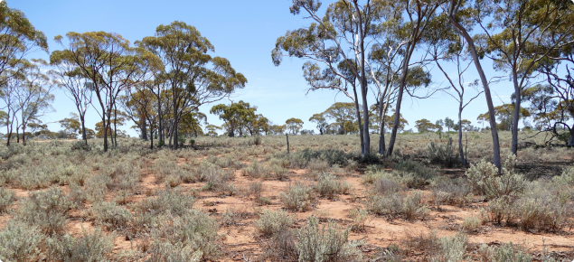
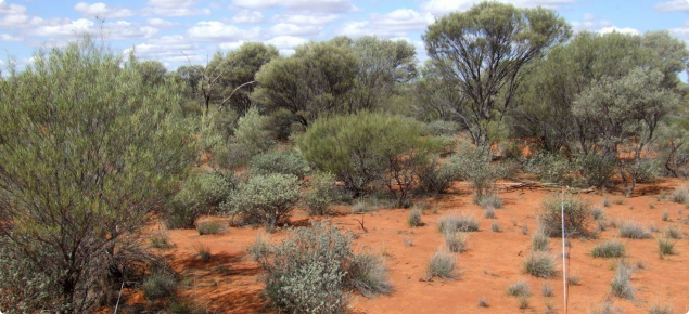
Good pasture condition: what to look for
- Desirable species (for the pasture type you are in) are dominant, vigorous and evenly spaced.
- Some intermediate perennial and annual plants may be present.
- Undesirable species are uncommon.
- Desirable species are reproducing; seedlings or young plants may be present.
- Groundcover is optimal for the site; sites with good soils and higher rainfall can generally support a higher density of plants than sites with shallow stony soils or lower rainfall.
- Where plants have been grazed down or burnt, the butts of desirable species are frequent and evenly spaced.
Fair pasture condition: what to look for
The density and diversity of desirable species are reduced for the pasture you are observing. Most of the palatable species are still present. Unpalatable species may have increased. Foliar cover is reduced compared with pastures in good condition unless an increase in unpalatable plants has occurred. Tree-based clumps are present but desirable species may be reduced or absent in the spaces between the clumps. Browse lines may be evident.
- Palatable species show signs of reduced vigour.
- Seedlings or young plants of desirable species are hard to find.
- Groundcover is less than optimal for the site. Patches of annual plants that were present have dried up, or have been trampled and blown away, leaving areas of bare ground.
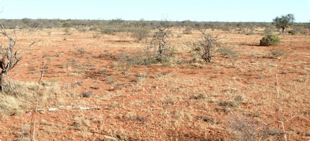
Poor pasture condition: what to look for
Intermediate and/or undesirable species dominate as dense stands or with variable amounts of bare ground. Palatable species may be absent. Foliar cover either decreases with a general loss of perennial plants or increases due to invasion by unpalatable plants. Tree-based clumps may break down and desirable species are absent in the spaces between the clumps. Browse lines are high and obvious, OR: bare ground dominates, with occasional perennial plants spaced far apart.
- Palatable species are rare or absent.
- Any palatable species remaining are usually stunted and unproductive.
- Intermediate species may be present but are less frequent compared to fair condition.
- Groundcover may be sparse or patchy.
- Large bare areas may be evident, particularly when the annual plants have dried up or been trampled and blown away.
References
Curry PJ, Payne AL and Wilcox DG (1983) 'Suggested descriptive terms for classes of foliar cover in arid zone shrublands', Range Management Newsletter, 83(3):12–13.
Tongway, DJ (1994) Rangeland soil condition assessment manual, CSIRO Australia, Division of Wildlife and Ecology, Canberra, 69 p.


