Summary
The South West Land Division (SWLD) has an equal chance of receiving neutral to below median rainfall for April to June 2024, according to the current model rainfall outlook.
Warmer temperatures than normal are expected to continue.
Things to consider:
-
Bureau of Meteorology temperature outlook for next 3 months, April to June 2024 and further ahead May to July, is for above average maximum and minimum temperatures (80% chance of exceeding median temperature).
-
From the models surveyed by the Bureau of Meteorology, 4 out of 7 are indicating a La Niña to develop in the Pacific Ocean by August. A La Nina has little influence on SWLD rainfall. Remember skill is poor at this time of the year.
-
All 5 models surveyed by the Bureau, indicate a positive Indian Ocean dipole (IOD) to develop in May. This may persist until at least August. A positive IOD means drier and warmer conditions in the SWLD. Remember skill is poor at this time of the year.
-
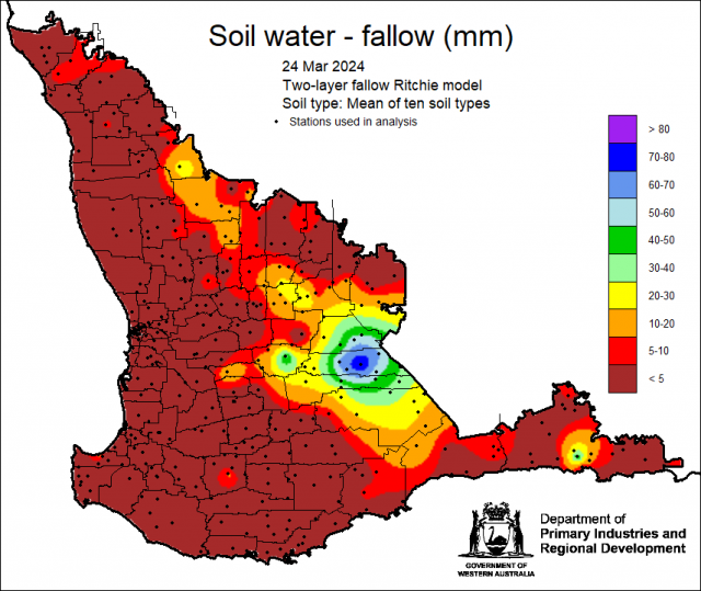
Latest DPIRD plant available soil water map indicates a high amount of water around Hyden, with low to none for other parts of the SWLD.
-
The Bureau’s Water and the Land is indicating only 1-5 mm rain along the south coast for the end of March.
Rainfall outlook for the South West Land Division
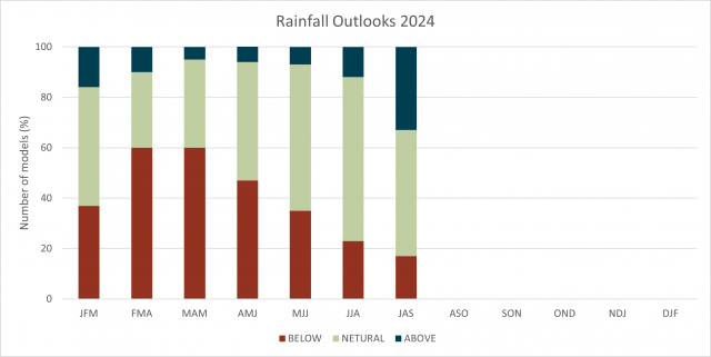
Summary of 19 national and international models show that 9 models indicate below median rainfall and another 9 indicate neutral chances of rainfall (above or below median) exceeding the median rainfall for the SWLD for April to June 2024.
Further ahead, the majority of models is indicating a neutral chance of exceeding median rainfall for winter, June to August and out to July to September.
A neutral outlook doesn’t mean average rainfall, but normal climatology (anything is possible). Remember, however, the further out the model forecasts, the least skill it has.
Also, because of the ‘autumn predictability barrier’ climate models forecasting past autumn (March to May), have the lowest skill and should be viewed with caution.
Climate driver outlook
The Bureau of Meteorology’s survey of international models shows 4 out of the 7 models are indicating a La Niña to develop in August. La Niña has little influence on the SWLD rainfall.
The last La Niña (without a negative IOD) was in 2020, a decile 2-3 growing season rainfall year.
The Bureau of Meteorology survey for the Indian Ocean Dipole (IOD), shows all models indicating a positive Indian Ocean Dipole in May, with some models, including the Bureau’s ACCESS model having the positive IOD lasting until at least August.
A positive IOD means drier winter-spring rainfall and warmer temperatures for SWLD. The last positive IOD was in 2019, a decile 2-3 growing season rainfall year.
Remember, that we are currently in the ‘autumn predictability barrier’ for forecasts, which means models predicting past autumn must be viewed with caution as they have the lowest skill at this time of the year.
For information on climate drivers refer to the Bureau of Meteorology’s Climate Driver Update.
Recent climate
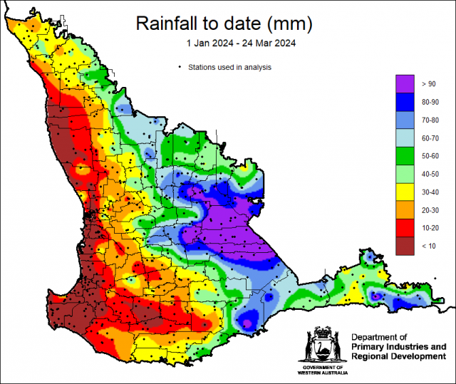
Rainfall 1 January to 24 March has been variable in the South West Land Division. The highest amount was in Hyden with 204 mm.
Current soil water map, which uses the two-layer fallow Ritchie model, indicates a high amount of plant available water for areas around Hyden.


