Recent climate
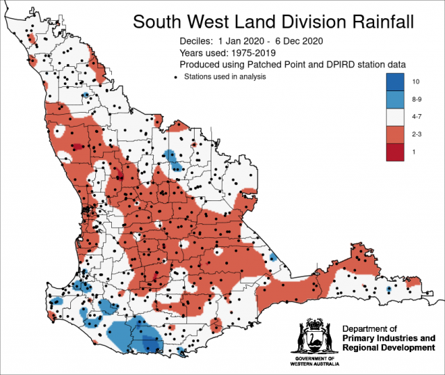
November rainfall was highest on record for Perth and seventh highest for Western Australia. November maximum temperatures were below average to average and minimum temperatures were generally average. Annual rainfall to date is generally below average in the SWLD.
In November, the atmospheric pressure was near normal over the SWLD.
Sea surface temperatures of the Indian Ocean north of Western Australia are warmer than average, this may be favourable for enhancing rainfall over the continent.
The Southern Annular Mode (SAM), also known as the Antarctic Oscillation (AAO), describes the north–south movement of the westerly wind belt that circles Antarctica, dominating the middle to higher latitudes of the southern hemisphere. SAM is currently positive and is expected to remain positive over the 2020-21 summer. La Niña tends to favour positive SAM during the spring to summer months, which typically enhances the wet signal of La Niña in parts of eastern Australia. For the SWLD, a positive SAM in summer has little effect on rainfall over WA, but increases temperatures as westerly winds are further south than normal, reducing the sea breeze along the WA coast. For more information see the Bureau of Meteorology’s Climate Driver Update.
The Indian Ocean Dipole (IOD) is neutral after tending towards positive values in recent months. With the Australian monsoon commencing, the IOD is likely to remain neutral through summer.
La Niña continues in the tropical Pacific. Australian and international climate models suggest it is likely to continue at least the end of February 2021. A La Niña is often associated with increased chance of widespread rains and flooding over eastern, central and northern Australia, more tropical cyclones than average and prolonged very warm periods in the south. In a La Niña, there is an increased chance of above average number of tropical systems (cyclones and lows) across northern Australia. The first Australian landfall typically occurs in early December, which is about 3 weeks earlier than usual. For further information, see the Bureau of Meteorology’s Australian Tropical Cyclone Outlook and the Northern Rainfall Onset.
The table below gives a summary of past month and three-month South West Land Division (SWLD) climate conditions, and can indicate what is likely to occur in the near future if climate conditions follow the current pattern.
| Climate Indicator | Past month | Past 3 months |
|---|---|---|
| SWLD Rainfall | Highest on record | Generally average |
| SWLD Mean Temperature | Very much above average | Above average |
| SWLD atmospheric pressure | Near normal | Higher |
| Indian Ocean Sea surface temperature | Warmer | Warmer |
| El Niño/Southern Oscillation (ENSO) | La Niña | La Niña |
| Indian Ocean Dipole (IOD) | Neutral | Neutral |
| Southern Annular Mode (SAM) | Positive | Positive |

