Recent climate
December rainfall was generally average in the SWLD. December maximum temperatures were average to above average and minimum temperatures were average.
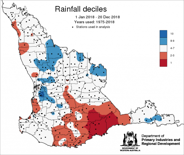
For 2018, January to December rainfall was decile 1 for the Jerramungup shire and parts of Gnowangerup, Kent and Ravensthorpe shires. Decile 2-3 rainfall for many shires in the Great Southern, average rainfall (decile 4-7) for the majority of the grainbelt and decile 8-9 rainfall for parts of Dalwallinu, Wongan Hills–Ballidu, Perenjori, Moora, Victoria Plains, Mount Marshall and Yilgarn shires.
It is important to note that historically, rainfall is very low for the months of January to February. However, localised and quick forming thunderstorms can bring heavy rainfall and statistical and dynamical climate forecasts can miss these weather systems.
In December, the atmospheric pressure was near normal over most of Australia. The Indian Ocean sea surface temperatures off the western WA coastline are expected to remain cooler than average, reducing the amount of moisture evaporated off the eastern Indian Ocean, and therefore likely limiting moisture flowing into WA.
The Southern Annular Mode (SAM), also known as the Antarctic Oscillation (AAO), describes the north–south movement of the westerly wind belt that circles Antarctica, dominating the middle to higher latitudes of the southern hemisphere. SAM is currently positive. In a positive SAM event, the belt of strong westerly winds contracts towards Antarctica, resulting in weaker than normal westerly winds and higher pressures over southern Australia, restricting the penetration of cold fronts inland. The National Oceanic and Atmospheric Administration (NOAA) suggests that SAM is likely to remain positive until mid-January.
The positive Indian Ocean Dipole (IOD) event has ended, and neutral IOD conditions prevail. The IOD typically has little influence on Australian climate from December to April. The IOD typically has little influence on Australian climate from December to April. See the Bureau of Meteorology’s IOD and Pacific Ocean interaction for details.
While tropical Pacific Ocean waters have warmed above El Niño levels, the atmospheric component of the El Niño–Southern Oscillation (ENSO) has not responded, meaning an El Niño event is yet to become established. Outlooks suggest waters are likely to remain at El Niño levels through the coming months, which will increase the chance of the atmosphere responding, particularly later in the season.
The table below gives a summary of past month and three month south-west Western Australia (SWWA) climate conditions, and can indicate what is likely to occur in the near future if climate conditions follow the current pattern.
| Climate indicator | Past month | Past three months |
|---|---|---|
| SWWA rainfall | Generally average | Generally average |
| SWWA mean temperature | Average to above | Average to above |
| SWWA atmospheric pressure | Near normal | Near normal |
| Indian Ocean sea surface temperature | Cooler | Cooler |
| El Niño/Southern Oscillation (ENSO) | Neutral | Neutral |
| Indian Ocean Dipole (IOD) | Neutral | Positive |
| Southern Annular Mode (SAM) | Positive | Positive |

