Summary
The Department of Primary Industries and Regional Development’s (DPIRD) Statistical Seasonal Forecast (SSF) system for autumn, March to May 2019, is indicating mixed chances of exceeding median rainfall for the South West Land Division (SWLD).
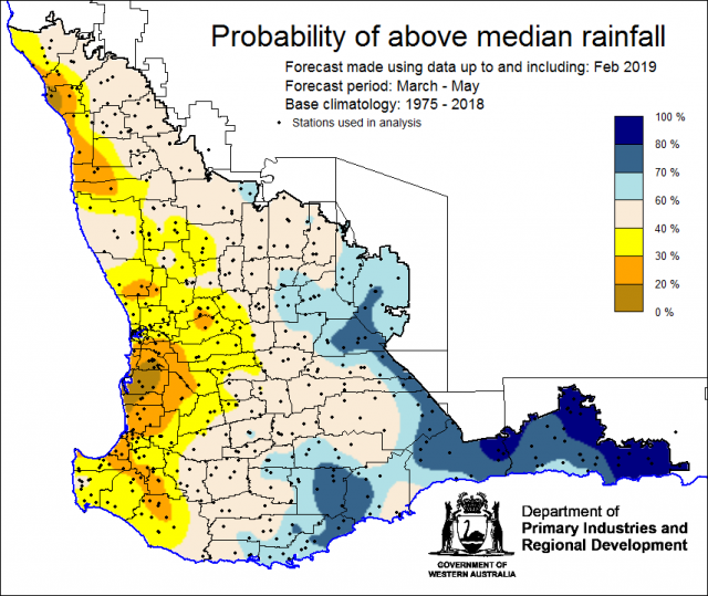
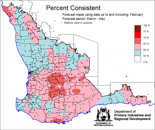
- For autumn, March to May 2019, the SSF is indicating less than a 40% chance of exceeding median rainfall for parts of the northern and central grainbelt, with greater chances (above 60%) for the far eastern grainbelt, South Coast and Esperance shires and neutral chances elsewhere. Most probable decile range is decile 2-3 for central and far northern grainbelt, decile 8-10 for eastern grainbelt, Ravensthorpe and Esperance shires and decile 4-7 elsewhere. Predictive skill based on February conditions is mostly poor to good (50 -70% consistent).
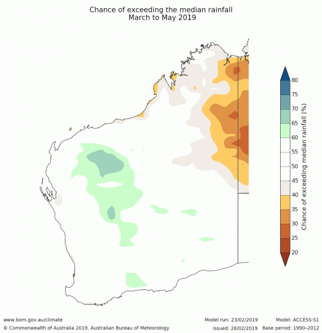
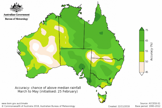
- The Bureau of Meteorology’s current seasonal outlook is indicating a neutral (45-60%) chance of exceeding median rainfall for March to May 2019 for the SWLD. Predictive skill is poor to moderate (45-65% consistent).
- Temperature outlooks for March to May 2019, from the Bureau indicate an over 80% chance of above average day-time maxima for the SWLD. Skill is mostly low to moderate at 45-65% consistent. Minimum temperature outlooks indicate greater than an 80% chance of above average night-time minima for the SWLD, with skill mostly poor at 45-55% consistent.
- February rainfall was generally below average in the SWLD. February maximum temperatures were above average and minimum temperatures were generally average.
- For seasonal forecasting, autumn is the 'predictability barrier', meaning the major climate drivers of El Niño/Southern Oscillation (ENSO) and Indian Ocean Dipole (IOD) are inactive. Therefore, seasonal forecasts have the lowest skill at this time of the year.
Three month seasonal forecast for the South West Land Division
Statistical Seasonal Forecasting (SSF)
DPIRD’s Statistical Seasonal Forecast (SSF) system uses historical relationships between global sea surface temperature and sea level pressure with rainfall in south-west Australia to produce forecasts of rainfall for the coming months. Users can click on any station indicated on the map for location-specific forecast information from the Seasonal Climate Information web page.
For autumn, March to May 2019, the SSF is indicating less than a 40% chance of exceeding median rainfall for parts of the northern and central grainbelt, with greater chances (above 60%) for the far eastern grainbelt, South Coast and Espererance shire. Neutral chances are for the reaminer of the SWLD. The most probable decile range is decile 2-3 for the central and far northern grainbelt, decile 8-10 for eastern grainbelt and Ravensthorpe and Esperance shires and decile 4-7 elsewhere. Predictive skill based on February conditions is mostly poor to good (50 -70% consistent).
Bureau of Meteorology seasonal climate outlook
The Bureau of Meteorology's climate forecast system for monthly and seasonal climate outlooks is the Australian Community Climate Earth-System Simulator – Seasonal (ACCESS–S1). It is a dynamical (physics-based) forecast modelling system and is a collaboration between the Bureau of Meteorology and the UK Meteorological Office.
The Bureau of Meteorology’s current seasonal outlook is indicating a neutral (45-60%) chance of exceeding median rainfall for autumn, March to May 2019 for the SWLD. Predictive skill is poor to moderate (45-65% consistent).
Temperature outlooks autumn, March to May 2019, from the Bureau indicate an over 80% chance of above average day-time maxima for the SWLD. Skill is mostly low to moderate at 45-65% consistent. Minimum temperature outlooks indicate greater than an 80% chance of above average night-time minima for the SWLD, with skill mostly poor at 45-55% consistent.
Recent climate
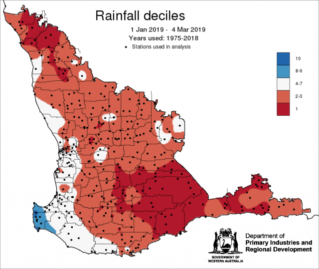
February rainfall was generally below average across the grainbelt. February maximum temperatures were above average and minimum temperatures were generally near average. Rainfall to date decile map for 1 January to 4 March, 2019 shows much of the grainbelt has recieved much less rainfall (decile 1-3) than usual based on historical rainfall for the years 1975-2018.
In February, the atmospheric pressure was above normal over most of Australia, reducing rainfall across parts of southern Australia.
The Indian Ocean sea surface temperatures off the western WA coastline is expected to remain cooler than average, reducing the amount of moisture evaporated off the eastern Indian Ocean, and therefore likely limiting moisture flowing into Western Australia.
The Southern Annular Mode (SAM), also known as the Antarctic Oscillation (AAO), describes the north–south movement of the westerly wind belt that circles Antarctica, dominating the middle to higher latitudes of the southern hemisphere. SAM was negative in the last 3 weeks but currently near neutral. A negative SAM event reflects an expansion of the belt of strong westerly winds towards the equator. Models indicate that SAM is likely to remain near neutral until mid-March.
The Indian Ocean Dipole (IOD) is forecast to remain neutral through autumn. The Bureau's ENSO Outlook is currently at El Niño WATCH, meaning there is a 50% chance of El Niño developing from autumn; this is double the normal chance. El Niño events typically mean drier than usual autumns in southern Australia. For further information, see the Bureau of Meteorology’s ENSO Wrap Up.
The table below gives a summary of past month and three-month southwest Western Australia (SWWA) climate conditions, and can indicate what is likely to occur in the near future if climate conditions follow the current pattern.
| Climate indicator | Past month | Past 3 months |
|---|---|---|
| SWWA Rainfall | Below average | Below average |
| SWWA Mean Temperature | Average to above average | Average to above average |
| SWWA atmospheric pressure | Above Normal | Above Normal |
| Indian Ocean Sea surface temperature | Cooler | Cooler |
| El Niño/Southern Oscillation (ENSO) | Neutral | Neutral |
| Indian Ocean Dipole (IOD) | Neutral | Neutral |
| Southern Annular Mode (SAM) | Negative | Positive |

