Note
An owner or occupier of land must give at least 90 days notice to the Commissioner of Soil and Land Conservation of an intent to drain subsurface water to control salinity and discharge that water onto other land, into other water or into a watercourse, even if on the same property. The notice must be in writing using the notice of intent to drain or pump (NOID) form. Principles and guidelines for inland drainage are covered in the Policy framework for inland drainage.
Drainage principles
These principles from the Policy framework for inland drainage are used during the NOID process.
- Drainage should be considered within an integrated catchment management framework, as part of the total water cycle, and quality and quantity of drainage water is managed.
- Environmental impacts, positive and negative, should be identified and described at a level appropriate to the scale of the drainage proposal. Proposals should demonstrate an overall environmental benefit.
- Public good from the proposal should be identified and be commensurate with the scale and risk of the proposal.
- Best practice for planning, design, consultation, construction and management should be used, appropriate to the scale and risks of the proposal.
- Consultation and participation is expected for stakeholders affected by drainage proposals.
- Costs for design, construction, operation and maintenance shall be identified, allocated and agreed for the life of the drainage proposal.
- Where necessary (depends on scale of the proposal), there should be documentation of governance, financial arrangements, and intentions for detailed design, access, construction, operation, maintenance, monitoring and evaluation, and allocation of liabilities.
Using leveed groundwater drains
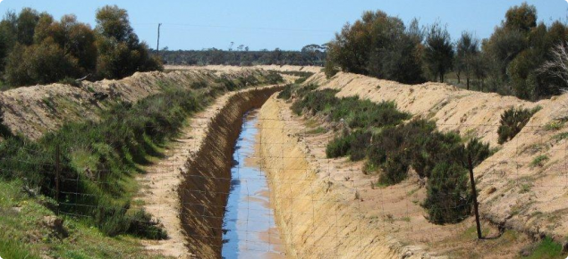
We recommend groundwater drains that are leveed on both sides to exclude surface water flows. Surface water flows are usually episodic and highly variable, which makes design of a drain to accommodate such flow very difficult and very expensive to construct.
Leveed deep drains can be used:
- on agricultural land where there are areas with suitable soils, low slope, shallow watertables, and waterlogging or surface salinity problems
- alone or with other practices (usually in combination with surface water management)
- clear of flow lines, streams, creeks and rivers
- where a small quantity of surface water flows overland outside of the structure, but is not diverted, concentrated or confined by the structure
- where a suitable outlet is available to dispose of the quantity and quality of water collected.
Planning considerations
- Identify services that are likely to be affected by the construction of the planned works. Plans are discussed with the service provider to confirm ways of avoiding disturbance or damage.
- Make allowance for vehicle, livestock and wildlife crossings. For very deep and steep-sided drains, consider escape structures for trapped livestock and wildlife.
- Determine the depth, quality and quantity of the water to be intercepted where a deep drain is to be installed to control subsurface flows. The texture of the water-bearing subsoil will determine permeability and flow rates.
- To create sufficient drawdown over a large area, multiple drains may be required at a calculated spacing.
- Establish the stability of the inlet, contained flow and outlet where a deep drain is installed to control flooding or waterlogging.
- The structure should not interfere with, divert or diminish the natural flow characteristics of any flow path.
Site assessment is critical for successful deep drains
The site assessment is the most important part in planning a deep drain. We recommend consulting a trained professional before investing in deep drains.
First, mark the intended channel line from the high point to the safe disposal point, then with a backhoe, put in about 5 pits per kilometre of the intended drain alignment to 2.5–3m depth.
In each pit observe:
- Soil horizons and soil type:
- Is the soil sandy or clayey? Heavy clay is less permeable and less suitable for deep drainage.
- From which horizon does the water flow? This will let you know how deep your drain may have to be.
- Soil characteristics which will give you an idea of the drain's effectiveness:
- possible barriers across the drain:
- dolerite dykes, coffee rock or tight clay horizons will make construction difficult.
- possible barriers across the drain:
- Time taken to establish a steady flow of water into the pit:
- in 1 hour the soil has good permeability
- in 12 hours the soil has average permeability
- in 24 hours the soil has poor permeability
- if the soil has poor permeability, it is unlikely that a deep drain will be effective due to low flow rates.
- Water quality in the drain:
- salinity level – a high electrical conductivity (EC) reading will determine where the drain water can be safely discharged
- acidity and heavy metal contamination – some groundwater can be highly acidic and can be naturally contaminated with heavy metals. This will determine where the drain water can be safely discharged
- take water samples and get them analysed by a reputable laboratory.
Design criteria
Site characteristics need to be accurately measured.
Soil types at the construction site: sample and test to determine the stability of the proposed structure.
Catchment peak flow run-off : calculate using a recognised method, such as the Flood Index Method or the Rational Method (see relevant chapters in the Australian Rainfall and Runoff site). Knowing the peak flow will confirm the likelihood of the structure overflowing and/or frequency of filling.
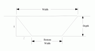
Channel cross-sectional shape: should be trapezoidal as in Figure 1.
Grade of channel should be constant and no greater than 0.2%.
Planning methodology – test holes or drilling determines the hydraulic conductivity and quality of subsurface flow. Darcy’s Law is used to determine the flow rate.
Determine the quantity of ponded water if this is to be piped underneath levees and into the channel. If flow is significant, the Manning formula and roughness coefficients are used to calculate the flow depth for channels with fixed widths.
Similarly, use the Manning formula and roughness coefficients to calculate channel flow depth and width, where the width is variable. In cases where channel depth and width are fixed, pipe numbers or pipe diameter can regulate the inflow of water.
Roughness coefficients and maximum permissible velocities, apply in these cases.
Drain spacing is determined by a recognised method, such as the steady state ellipse equation, if drains are to be installed to lower a watertable over a large area. See the Department of Water and Environmental Regulation cone of depression online calculator.
Sideslope ratios: are determined from soil type and drain depth, as suggested in Table 1.
| Soil type | Shallow channels to 1.2 m deep (horizontal : vertical) | Deep channels 1.2 m and deeper (horizontal : vertical) |
|---|---|---|
| Sand – clayey sand | 2 : 1 | 3:1 |
| Sandy loam – silt loam | 1.5 : 1 | 2 : 1 |
| Sandy clay loam – light clay | 1 : 1 | 1.5 : 1 |
| Light medium clay – heavy clay | 0.5 : 1 | 1 : 1 |
Channel base width may be single excavator bucket width, or multiples of bucket width. Where ponded water is significant and piped under levees, width is determined by design criteria.
Maximum drain length – there is no maximum allowed, but longer drains and drain networks require more detailed design and construction. Cross-sectional area of longer drains should increase down the length to cope with increased volumes of water.
Depth is to about 2 or 3 metres. Note that a consistent grade of the base of the channel is more important than a consistent depth.
Cross fall of channel floor is ideally zero.
Spoil banks are placed both sides of the channel to form levees should not obstruct surface water flows. Placing spoil clear of excavation creates a berm or ledge between the channel and spoil. The berm allows access for machinery maintaining the channel and helps prevent spoil from washing or rolling into the channel.
To minimise slumping, spoil is shaped into a bank with side slope ratios as suggested below. Adequate cross-section flow and suitable surface flow must be available outside of the levees to accommodate the predicted surface flow.
Where the channel is used to intercept subsurface flow and ponded surface water, ponded water can be piped under spoil/levee and into the channel. Rate of discharge to the drain should be kept low. Berm and spoil/levee are constructed both sides of the channel (Figure 2).
Outlets shall be stable and of sufficient capacity to prevent ponding or erosion. The outlet can be another channel or natural waterway. Shallow basins, appropriately designed, can be used to evaporate saline subsurface flows where no other safe outlet exists. The drain should become shallower at the discharge end or have an engineered and reliable water removal system. The outlet must not lead to unacceptable environmental, social or economic damage.
Vegetation cover: Annual or perennial pasture grass species or a mixture of both should be encouraged on spoil, berm and channel side slopes to stabilise the surface. If trees and shrubs are to be incorporated, plant them well outside the levee banks. Do not compromise surface water earthworks, and allow sufficient space for maintenance access in the long term.
Fencing: Is recommended, and should be outside the spoil banks, maintenance tracks and any tree or shrub planting. Fencing will prevent livestock falling into the drains.
Legal and environmental aspects
Legal aspects – common and statute
Common law rules govern the flow of surface water from artificial drains and underground water that is discharged into watercourses. Artificial drainage must be constructed so it does not impact or have a detrimental effect on streams further down the catchment.
Take reasonable steps to ensure the safety of others or another person's property.
Consider the effect that planned earthworks will have on other people and seek consent from any person that may be affected.
Due care must be taken during construction and maintenance to stop the loss of disturbed material from the site.
Under Regulation 5 of the Soil and Land Conservation Act 1945, the land owner or occupier proposing to 'drain or pump water from under the land surface because of salinity of the land or the water, and to discharge that water onto other land, into other water or into a watercourse' to notify the Commissioner of Soil and Land Conservation (the Commissioner) of that intent at least 90 days prior to discharging the water, using the notice of intent to drain or pump water (NOID) form.
For proposals to drain land within the Peel–Harvey Catchment, proponents must submit a notice of intent to drain or pump water (NOID) to the Commissioner at least 90 days before draining surface or subsurface water onto other land, into other water or into a watercourse
Interference with a watercourse in a proclaimed surface water management area is controlled under the provisions of the Rights in Water and Irrigation Act 1914 (WA).
The Occupational Safety and Health Act 1984 sets objectives to promote and improve occupational safety and health standards. This Act sets out broad duties and is supported by more detailed requirements in the Occupational Safety and Health Regulations 1996.
The legislation is further supported by guidance material such as approved Codes of Practice through WorkSafe Western Australia. ‘Code of Practice – Excavations’ applies to all workplaces where excavation occurs, and particularly when 'a person is required to work in an excavated area or other opening in the ground that is at least 1.5 metres deep'.
Environmental aspects
Flows of poor quality water (saline, acid, heavy metals) can degrade channels, watercourses and wetlands for many kilometres downstream of the discharge point. Refer to the Department of Water and Environmental Regulation's acid sulfate soils website.
Eroded material from poorly planned, constructed or maintained drainage systems can reduce flow capacities when deposited in downstream channels.
Deep drains are effective barriers for livestock and a lot of wildlife, and a trap for animals that may fall into the drain. Fencing can keep larger animals out, but smaller animals falling into the drain will need some form of escape chute at regular intervals. This is especially important if deep drains cross areas of bush or vegetation corridors.
Construction
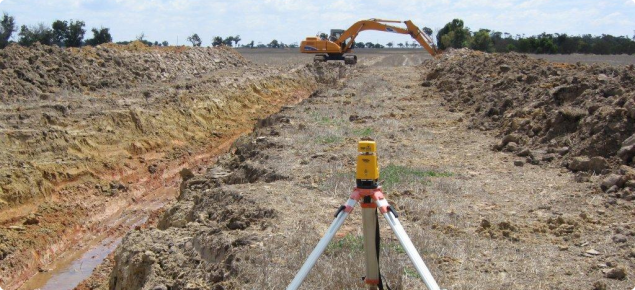
- The drains are usually constructed with an excavator. A bulldozer or grader may be used to shape the spoil into levees and provide a channel for surface flows.
- Peg the centre of the channel for alignment as indicated on the plan. Cut and/or slope will be surveyed to indicate the depth to the channel floor.
- Channel will be excavated to line and on grade as detailed on the plan. Check and maintain the channel grade by using a level.
- Sideslope ratios can be confirmed by using an electronic builders slope finder or battometer.
- Spoil shall be placed and shaped as indicated on the plan.
- Design and implement suitable crossings and culverts, especially if the drains cross roads.
Operation and maintenance
- Follow the agreed monitoring and evaluation schedule, in accordance with any approvals or conditions.
- Damaged channel sideslopes or spoils banks to be reconstructed to original specifications.
- Cleaning of deep drains is required after about 5 years to remove mud and chemical seals on the side walls which block discharge into the drain.
- Silt or eroded material to be removed from the channel and incorporated into spoils banks to original specifications.
- If piped inlets have been incorporated, they require regular inspection to remove debris and to check for damage.
Reference material
- Bligh, KJ 1989, Soil conservation earthworks design manual, Department of Agriculture, Western Australia, Perth.
- Clement, J, Bennett, M, Kwaymullina, A & Gardner, A 2001, The law of landcare in Western Australia, 2nd edn, Environmental Defender’s Office WA (Inc), Perth, Western Australia.
- Houghton, PD & Charman, PEV 1986, Glossary of terms used in soil conservation, Soil Conservation Service of New South Wales.
- Hudson, N 1992, Soil conservation, B. T. Batsford Ltd., London, England.
- McCuen, RH 1989, Hydrologic analysis and design, 2nd edn, Department of Engineering, University of Maryland, Prentice Hall, Upper Saddle River, New Jersey, USA.
- Moore, GA 2001, 'Soil guide: a handbook for understanding and managing agricultural soils', Bulletin 4343, Department of Agriculture and Food, Western Australia, Perth.
- Pilgrim, DH 1987, Australian rainfall and runoff, The Institution of Engineers, Australia, Barton, ACT.
- Schwab, GO, Fangmeier, D, Elliot, W, & Frevert, R 1992, Soil and water conservation engineering, 4th edn, John Wiley and Sons Inc., Toronto, Canada.
Support and extension material
- Keen, MG 1998, Common conservation works used in Western Australia, Agriculture Western Australia, Perth.
- Keen, MG 2001, Field pocket book of conservation earthworks formulae and tables, Department of Agriculture, Western Australia, Perth.
Planning, pegging and construction skills
National competencies exist for the conservation earthworks industry and are detailed as part of the Agriculture, Horticulture and Conservation and Land Management Training Package.
The relevant qualification is:
AHC32316: Certificate III in Conservation Earthworks


