Summary
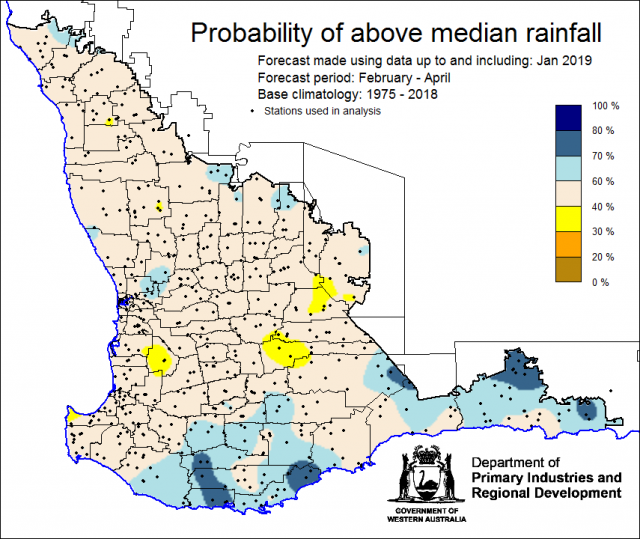
The Department of Primary Industries and Regional Development’s (DPIRD) Statistical Seasonal Forecast (SSF) system for February to April 2019 is indicating generally neutral chances (40-60%) of exceeding median rainfall for the South West Land Division (SWLD).
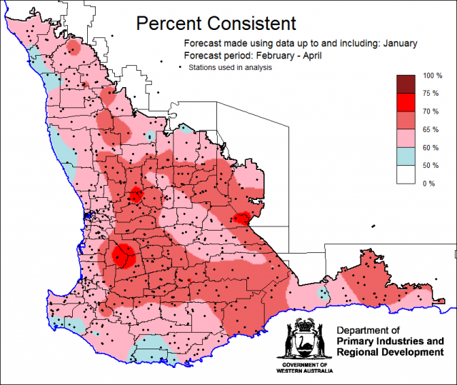
- For February to April 2019, the SSF is indicating a neutral (40 - 60%) chance of exceeding median rainfall for the majority of the grainbelt, with greater chances (60-80%) for Esperance and the Great Southern region. Most probable decile range is decile 4-7 for most of the grainbelt and decile 8-9 for Esperance and Great Southern. Predictive skill based on January conditions is mostly poor to good (50 - 70% consistent).
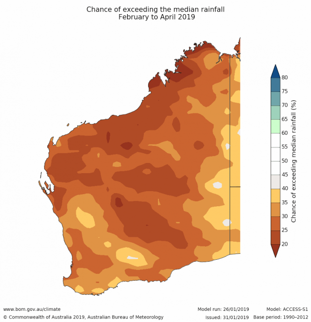
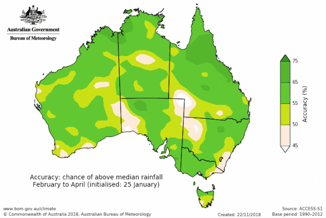
- The Bureau of Meteorology’s current seasonal outlook is indicating less than 40% chance of exceeding median rainfall for February to April 2019 for the SWLD. Predictive skill is poor to moderate (45-65% consistent).
- Temperature outlooks February to April 2019, from the Bureau indicate over 80% chance of above average day-time maxima for the SWLD. Skill is mostly moderate at 50-65% consistent. Minimum temperature outlooks indicate over 70% chance of above average night-time minima for most of the SWLD, parts of the southern coasts chances are higher than the south west forecast district , with skill mostly moderate at 50-65% consistent.
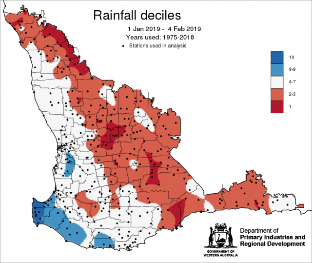
- January rainfall was generally below average to average in the SWLD grainbelt, with above average in the southwest capes. January maximum temperatures were average to above average and minimum temperatures were below average to average.
Three Month Outlook for the south-west of Western Australia
Statistical Seasonal Forecasting (SSF)
DPIRD’s Statistical Seasonal Forecast (SSF) system uses historical relationships between global sea surface temperature and sea level pressure with rainfall in south-west Australia to produce forecasts of rainfall for the coming months. Users can click on any station indicated on the map for location-specific forecast information from the Seasonal Climate Information web page.
For February to April 2019, the SSF is indicating for a neutral 40-60% chance of exceeding median rainfall for the South West Land Division. The most probable decile range is decile 4-7 for most of the grainbelt and decile 8-9 for Esperance and Great Southern region. Predictive skill based on January conditions is mostly poor to good (50-75% consistent).
Bureau of Meteorology seasonal climate outlook
The Bureau of Meteorology's climate forecast system for monthly and seasonal climate outlooks is called the Australian Community Climate Earth-System Simulator – Seasonal (ACCESS–S). It is a dynamical (physics-based) forecast modelling system and is a collaboration between the Bureau of Meteorology and the UK Meteorological Office.
The Bureau of Meteorology’s current seasonal outlook is indicating a less than 40% chance of exceeding median rainfall for February to April 2019 for the South West Land Division (SWLD). Predictive skill is poor to moderate (45-65% consistent).
Temperature outlooks February to April 2019, from the Bureau indicate 80% chance of above average day-time maxima for the SWLD. Skill is moderate to good at 50-65% consistent. Minimum temperature outlooks indicate greater than 70% chance of above average night-time minima (lower chances along the coast) for most of the, with skill mostly moderate at 50-65% consistent.
Recent climate
January rainfall was generally below average to average in the SWLD. January maximum temperatures were average to above average and minimum temperatures were below average to average. Rainfall to date decile map for 1 January to 4 February 2019 shows much of the grainbelt has received less rainfall (decile 2-3) than usual based on historical rainfall for the years 1975-2018.
In January, the atmospheric pressure was above normal over most of Australia. The Southern Ocean is likely to see higher pressures and weaker westerly winds, most noticeable during February, to the southwest of Australia. This may reduce rainfall across parts of southern Australia.
The Indian Ocean sea surface temperatures off the western WA coastline is expected to remain cooler than average, reducing the amount of moisture evaporated off the eastern Indian Ocean, and therefore likely limiting moisture flowing into Western Australia.
The Southern Annular Mode (SAM), also known as the Antarctic Oscillation (AAO), describes the north–south movement of the westerly wind belt that circles Antarctica, dominating the middle to higher latitudes of the southern hemisphere. SAM is currently positive. In a positive SAM event, the belt of strong westerly winds contracts towards Antarctica, resulting in weaker than normal westerly winds and higher pressures over southern Australia, restricting the penetration of cold fronts inland. Models indicate that SAM is likely to remain positive until mid-February.
The Indian Ocean Dipole (IOD) is neutral. The IOD typically has little influence on Australian climate from December to April. The El Nino Southern Oscillation (ENSO) remains neutral. There is a 50% chance of an El Nino developing during autumn. El Nino’s typically result in warmer and drier than usual conditions, and a later autumn break for southern and eastern Australia. Further information can be obtained from the Bureau of Meteorology’s ENSO Wrap Up.
The table below gives a summary of past month and three-month southwest Western Australia (SWWA) climate conditions, and can indicate what is likely to occur in the near future if climate conditions follow the current pattern.
| Climate Indicator | Past month | Past 3 months |
| SWWA Rainfall | Below average to average | Below average to average |
| SWWA Mean Temperature | Average to above | Average to above |
| SWWA atmospheric pressure | Above Normal | Above Normal |
| Indian Ocean Sea surface temperature | Cooler | Cooler |
| El Niño/Southern Oscillation (ENSO) | Neutral | Neutral |
| Indian Ocean Dipole (IOD) | Neutral | Neutral |
| Southern Annular Mode (SAM) | Positive | Positive |

