Summary
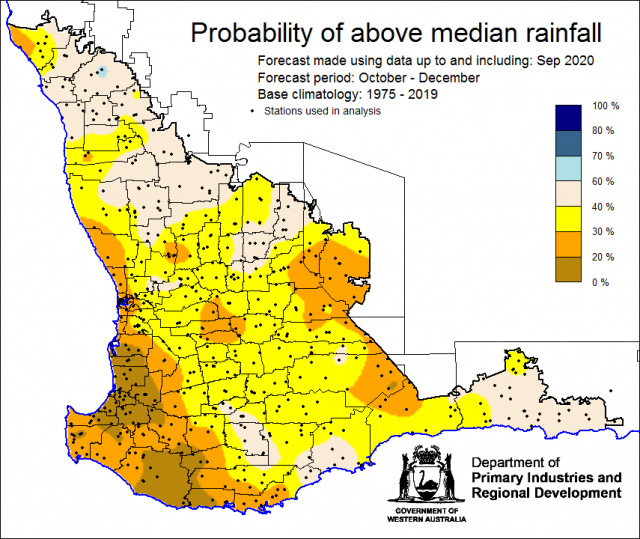
The Department of Primary Industries and Regional Development’s (DPIRD) Statistical Seasonal Forecast (SSF) outlook for October to December is generally less than 40% chance of exceeding median rainfall for the majority of the South West Land Division.
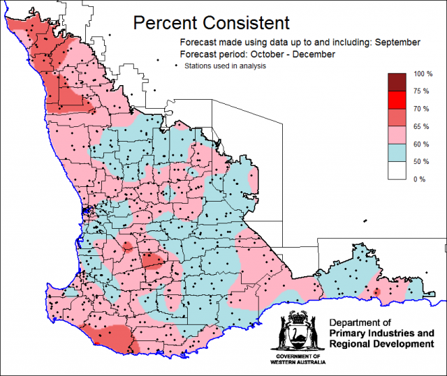
- For October to December, the SSF is generally less than 40% chance of exceeding median rainfall for the majority of the South West Land Division. The most probable rainfall decile map indicates decile 2-3 for the majority of the SWLD. Predictive skill based on September conditions is poor to moderate (50-70% consistent).
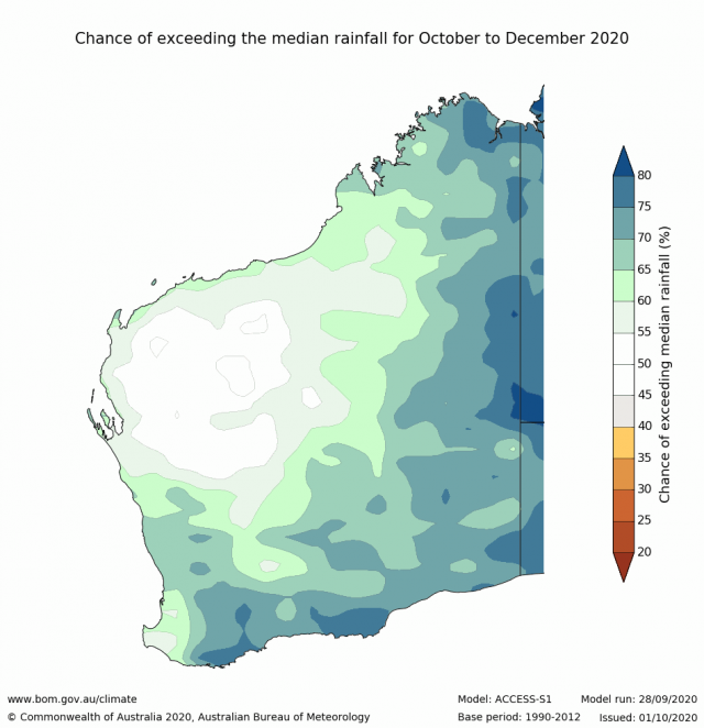
- The Bureau of Meteorology’s current seasonal outlook is indicating 60-80% of exceeding median rainfall for October to December 2020 for the majority of the South West Land Division. Predictive skill is good (65% consistent). The longer-term outlook for November to January 2021 is similar. Predictive skill is poor to good (45-65%).
- Temperature outlooks for October to December 2020, from the Bureau indicate a 30-60% chance of above average day-time maxima (skill very high above 75%) and 60-80% chance of above average night-time minima (skill very high above 75%) for the SWLD.
- September rainfall was below average in the Central West and parts of the Central wheatbelt and Esperance shire, above average in the south west and average elsewhere. September maximum temperatures were very much above average. September minimum temperatures were above average.
- A La Niña has developed in the Pacific Ocean, this will increase the chance of rainfall for eastern Australia. In a La Niña, there is an increased chance of above average number of tropical systems (cyclones and lows) across northern Australia. This may lead to more summer rainfall in the SWLD.
Three Month Outlook for the south-west of Western Australia
Statistical Seasonal Forecasting (SSF)
DPIRD’s Statistical Seasonal Forecast (SSF) system uses historical relationships between global sea surface temperature and sea level pressure with rainfall in south-west Australia to produce forecasts of rainfall for the coming months. Users can click on any station indicated on the map for location-specific forecast information from the Seasonal Climate Information web page.
For October to December, the SSF is generally less than 40% chance of exceeding median rainfall for the majority of the South West Land Division. The most probable rainfall decile map indicates decile 2-3 for the majority of the SWLD. Predictive skill based on September conditions is poor to moderate (50-70% consistent).
Bureau of Meteorology seasonal climate outlook
The Bureau of Meteorology's climate forecast system for monthly and seasonal climate outlooks is the Australian Community Climate Earth-System Simulator – Seasonal (ACCESS–S). It is a dynamical (physics-based) forecast modelling system and is a collaboration between the Bureau of Meteorology and the UK Meteorological Office.
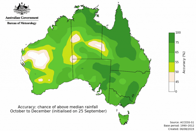
The Bureau of Meteorology’s current seasonal outlook is indicating 60-80% of exceeding median rainfall for October to December 2020 for the majority of the South West Land Division. Predictive skill is good (65% consistent). The longer-term outlook for November to January 2021 is similar. Predictive skill is poor to good (45-65%).
Temperature outlooks for October to December 2020, from the Bureau indicate a 30-60% chance of above average day-time maxima (skill very high above 75%) and 60-80% chance of above average night-time minima (skill very high above 75%) for the SWLD.
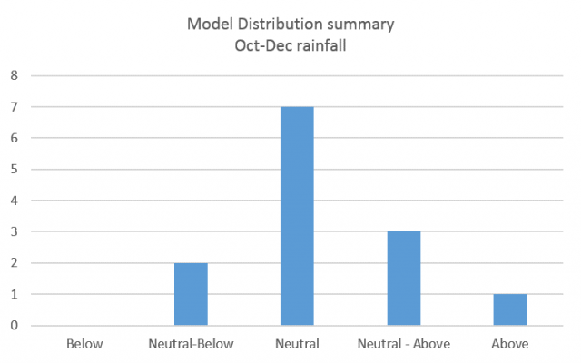
Looking at other rainfall forecasting models, the majority are indicating neutral chance of exceeding median rainfall for October to December for the South West Land Division.
Recent climate
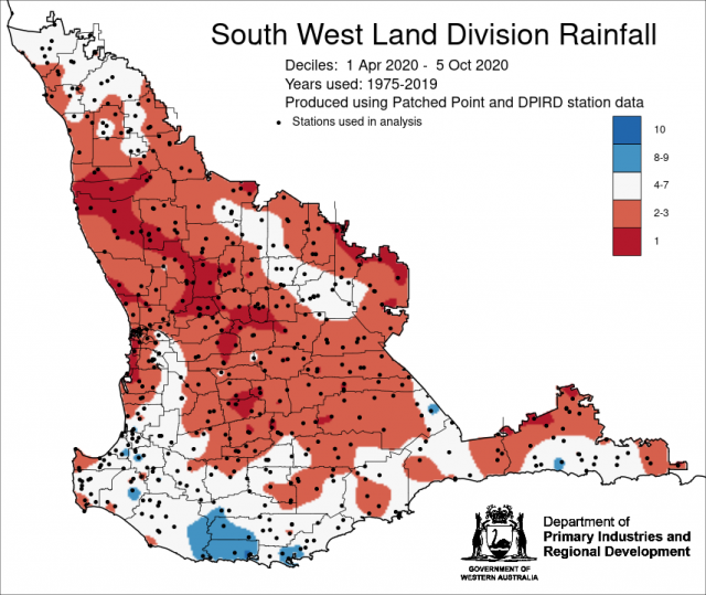
September rainfall was below average in the Central West and parts of the Central wheatbelt and Esperance shire, above average in the south west and average elsewhere. September maximum temperatures were very much above average. September minimum temperatures were above average. Rainfall from 1 April to date has generally beendecile 2-3 in the SWLD.
In September, the atmospheric pressure was near normal over the SWLD.
Sea surface temperatures of the Indian Ocean north of Western Australia are warmer than average. The September to November 2020, SST forecast by the Bureau of Meteorology indicates SSTs are likely to remain warm, north of WA.
The Southern Annular Mode (SAM), also known as the Antarctic Oscillation (AAO), describes the north–south movement of the westerly wind belt that circles Antarctica, dominating the middle to higher latitudes of the southern hemisphere. The Southern Annular Mode (SAM) is expected to be neutral or weakly positive for the first three weeks of October . For more information see the Bureau of Meteorology’s Climate Driver Update.
Large parts of the central and eastern Indian Ocean are warmer than average, with surface temperatures close to average in much of the west of the basin. The latest weekly value of the Indian Ocean Dipole (IOD) index to 4 October was -0.06, returning to neutral dipole values. Five of the six surveyed climate models indicate values indicate the IOD will be negative in October, and three continue the event into November. To be considered an official negative IOD event we will need to see values of the IOD index remain at or cooler than −0.4 °C for eight weeks. A negative IOD typically brings above average spring rainfall to most of the eastern two thirds of Australia and to south-east Western Australia.
A La Niña has established in the Pacific Ocean. All models are indicating this to last until January 2021. A La Niña is often associated with increased chance of widespread rains and flooding over eastern, central and northern Australia, more tropical cyclones than average and prolonged very warm periods in the south. In a La Niña, there is an increased chance of above average number of tropical systems (cyclones and lows) across northern Australia. The first Australian landfall typically occurs in early December, which is about 3 weeks earlier than usual. For further information, see the Bureau of Meteorology’s Climate Driver Update and the Northern Rainfall Onset.
The table below gives a summary of past month and three-month South West Land Division (SWLD) climate conditions, and can indicate what is likely to occur in the near future if climate conditions follow the current pattern.
| Climate Indicator | Past month | Past 3 months |
|---|---|---|
| SWLD Rainfall | Mixed | Below average to average |
| SWLD Mean Temperature | Very much above average | Very much above average |
| SWLD atmospheric pressure | Near Normal | Higher |
| Indian Ocean Sea surface temperature | Warmer | Warmer |
| El Niño/Southern Oscillation (ENSO) | La Niña | Neutral |
| Indian Ocean Dipole (IOD) | Neutral | Neutral |
| Southern Annular Mode (SAM) | Negative | Negative |

