Recent climate
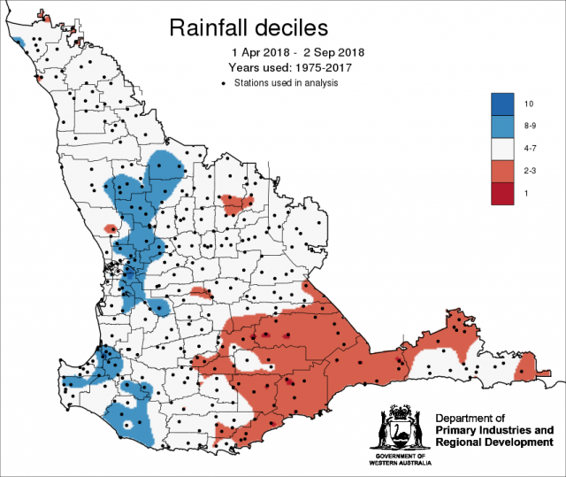
August rainfall was generally above average for the grainbelt and average in the Great Southern. Winter rainfall (June to August) was generally average, with small parts of the Great Southern receiving below rainfall. The SSF was indicating a below average winter and the Bureau’s POAMA model indicated neutral conditions in the June Seasonal Climate Outlook. August maximum and minimum temperatures were generally average. The rainfall deciles map for 1 April-2 September shows large parts of the grainbelt have received average rainfall (decile 4-7), some parts of the northern agricultural region has received decile 8-9 rainfall, and the southern grainbelt and northern Esperance region is tracking at decile 2-3.
In August the atmospheric pressure was lower than normal over southern Australia, bringing in cold fronts to SWLD. The Indian Ocean sea surface temperatures continue to be cooler than average to Australia's northwest, which is likely acting to suppress rainfall over southern and central Australia.
The Southern Annular Mode (SAM), also known as the Antarctic Oscillation (AAO), describes the north–south movement of the westerly wind belt that circles Antarctica, dominating the middle to higher latitudes of the southern hemisphere. SAM is currently positive. In a positive SAM event, the belt of strong westerly winds contracts towards Antarctica, resulting in weaker than normal westerly winds and higher pressures over southern Australia, restricting the penetration of cold fronts inland. The Bureau’s POAMA model suggests that SAM is likely to remain positive until mid-September.
The Indian Ocean Dipole (IOD) is neutral. However, models suggest a brief positive IOD event may form during spring. A positive IOD event typically reduces winter–spring rainfall in central and southern Australia, and can exacerbate any El Niño driven rainfall deficiencies. See the Bureau of Meteorology’s IOD and Pacific Ocean interaction for details.
The El Niño-Southern Oscillation is currently neutral, but there is a 50% chance (double the normal risk) of El Niño forming in the coming months. El Niño typically means below average rainfall during spring for northern and eastern Australia and warmer days for the southern two-thirds of the country.
The table below gives a summary of past month and three month south-west Western Australia (SWWA) climate conditions, and can be used as an indication of what is likely to occur in the near future if climate conditions follow the current pattern.
| Climate Indicator | Past month | Past three months |
| SWWA rainfall | Above average | Generally average |
| SWWA mean temperature | Generally average | Average to above |
| SWWA atmospheric pressure | Lower | Lower |
| Indian Ocean sea surface temperature | Cooler | Near normal |
| El Niño/Southern Oscillation (ENSO) | Neutral | Neutral |
| Indian Ocean Dipole (IOD) | Neutral | Neutral |
| Southern Annular Mode (SAM) | Positive | Near neutral |

