Summary
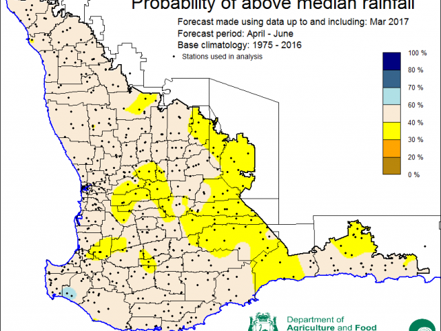
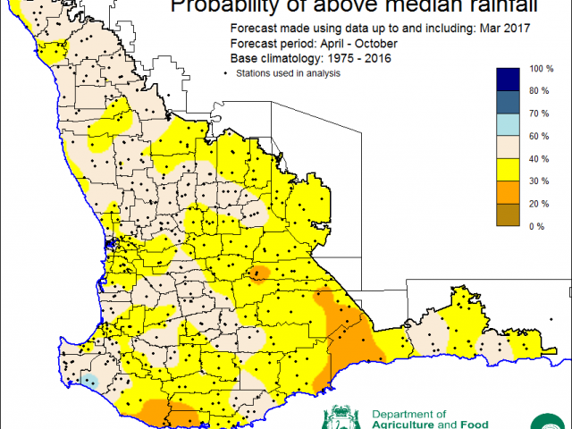
The Department of Agriculture and Food, Western Australia’s Statistical Seasonal Forecast (SSF) system is indicating below median rainfall for the majority of the South West Land Division (which includes the Wheatbelt) for April to June and April to October 2017.
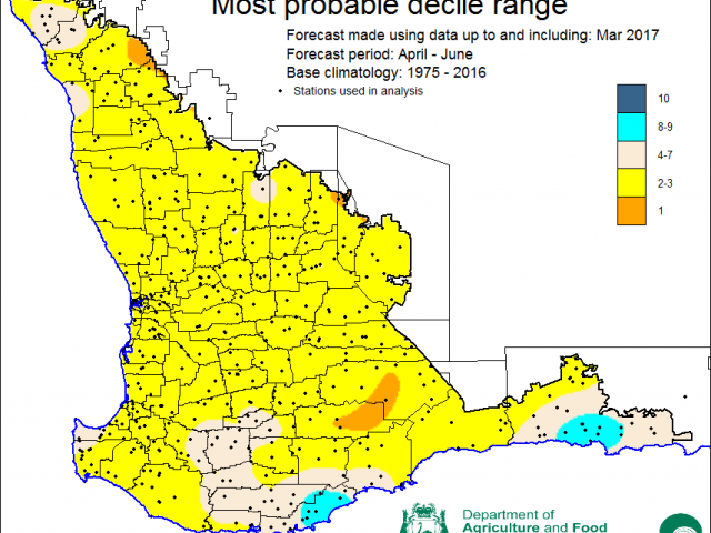
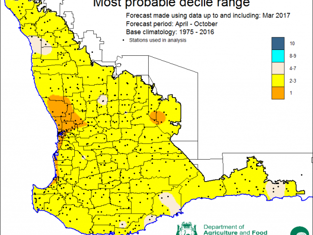
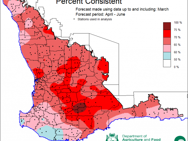
- The SSF is indicating 30-60% chance of exceeding median rainfall for the majority of the Wheatbelt. The most probable decile range map indicates decile 2-3 rainfall is most likely for April to June. Predictive skill based on March conditions is poor to good (50-100% consistent).
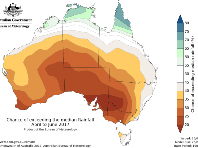
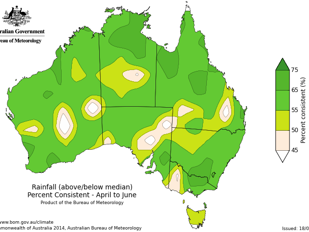
- The Bureau of Meteorology’s current seasonal outlook indicates the South West Land Division (SWLD) has a 20-35% chance of exceeding median rainfall for April to June. Predictive skill is moderate to good (55-75% consistent).
- Temperature outlooks for April to June from the Bureau indicate a 35-60% chance of above normal day-time maxima for the south-west corner. For the Wheatbelt, chances are higher at 60-70%. Skill is moderate to good at 55-75% consistent. Minimum temperature outlooks indicate a 30-65% chance of above normal night-time minima for SWLD, with skill poor to moderate at 50-65% consistent.
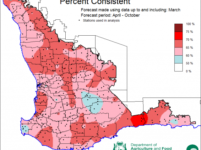
- DAFWA’s SSF is indicating a 20-60% chance of exceeding median rainfall for April to October. The most probable decile range map indicates rainfall decile of 2-3 for the majority of the South West Land Division. Predictive skill based on March conditions is poor to good (50-75% consistent).
- Rainfall in March was average to above average for most of the SWLD. Maximum temperatures were below average (decile 2-3), whilst minimum temperatures were average.
Three month outlook for the south-west of Western Australia
Statistical seasonal forecasting (SSF)
DAFWA’s Statistical seasonal forecast (SSF) system uses historical relationships between global sea surface temperature and sea level pressure with rainfall in south-west Australia to produce forecasts of rainfall for the coming months. Users can click on any station indicated on the map for location-specific forecast information from the Seasonal Climate Information page.
The SSF forecast April to June 2017 is indicating 30-60% chance of exceeding median rainfall. The most probable decile range map indicates decile 2-3 rainfall for April to June for the majority of the South West Land Division. Predictive skill based on March conditions is poor to moderate (50-70% consistent).
Bureau of Meteorology seasonal climate outlook
The Bureau of Meteorology’s climate outlooks are generated by a dynamical (physics based) coupled atmosphere-ocean climate model.
The Bureau of Meteorology’s current seasonal outlook indicates the South West Land Division (SWLD) has a 20-35% chance of exceeding median rainfall for April to June. Predictive skill is moderate to good (55-75% consistent). The Bureau’s drier outlook is influenced by warming in tropical Pacific sea surface temperatures and a cooler eastern Indian Ocean.
Temperature outlooks for April to June from the Bureau indicate a 35-60% chance of above normal day-time maxima for the south-west corner. For the Wheatbelt, chances are increased to 60-70%. Skill is moderate to good at 55-75% consistent. Minimum temperature outlooks indicate a 30-65% chance of above normal night-time minima for the SWLD, with skill poor to moderate at 50-65% consistent.
Growing season outlook (April-October) for the south-west of Western Australia
DAFWA’s SSF is indicating a 20-60% chance of exceeding median rainfall for April to October. The most probable decile range map indicates rainfall decile of 2-3 for the majority of the South West Land Division. Predictive skill based on March conditions is poor to good (50-75% consistent).
Recent climate
Rainfall in March was average to above average for most of the South West Land Division. The last three months, January to March was very much above average, both the Bureau and DAFWA outlooks saw probabilities close to 50% for this period and so offered little guidance (See January edition of the Seasonal Climate outlook). Check DAFWA rainfall to date tool and DAFWA soil water tool for rainfall totals and modelled stored soil moisture estimates.
March South West Land Division maximum temperatures were below average (decile 2-3), whilst minimum temperatures were near average.
The far eastern Pacific Ocean has warmed substantially, with temperatures now more than three degrees above average. While this is unlikely to be affecting Australia’s climate right now, models suggest this local warming will spread across more of the tropical Pacific. The Bureau of Meteorology’s ENSO Outlook has moved to El Niño WATCH, as seven of eight climate models we survey suggest El Niño during winter. An El Niño typically biases Australia's climate towards a drier than average winter-spring (for eastern Australia), and warmer daytime temperatures in the south.
The Indian Ocean Dipole (IOD) remains neutral. The IOD has little influence on Australia from December to April. Five out of six models are indicating a positive IOD by August, which means a greater likelihood of reduced rainfall for the SWLD in winter and spring. In the past, a positive IOD combined with an El Nino has meant reduced rainfall for winter and spring for SWWA. See the Bureau of Meteorology’s IOD and Pacific Ocean interaction for details.
Indian Ocean sea surface temperatures (SSTs) north and west of Australia have cooled in the past month and now are below average. This means that heavy rainfall events from cold fronts are less likely as there is less warmth in the ocean to the west and a weaker north/south temperature gradient. For a summary of Pacific and Indian Ocean outlooks, see the Climate Model Summary produced by the Bureau.
The Southern Annular Mode (SAM), also known as the Antarctic Oscillation (AAO), describes the north–south movement of the westerly wind belt that circles Antarctica, dominating the middle to higher latitudes of the southern hemisphere. SAM is currently positive and is expected to remain so through April. A positive SAM in autumn can mean drier conditions for the south-west corner though has a limited impact on the Wheatbelt.
In March the atmospheric pressure was lower than normal over the south-west. The mean sea level pressure is forecast to be higher in the coming months, meaning fewer cold fronts are likely to cross the coast.
The table below gives a summary of past month and three month south-west Western Australia (SWWA) climate conditions, and can be used as an indication of what is likely to occur in the near future, if climate conditions follow the current pattern.
| Climate Indicator | Past month | Past three months |
|---|---|---|
| SWWA rainfall | Average to above average | Above average |
| SWWA mean temperature | Average to below average | Below average |
| SWWA atmospheric pressure | Lower to normal | Normal |
| Indian Ocean sea surface temperature | Cooler | Cooler |
| El Nino/Southern Oscillation (ENSO) | Neutral | Neutral |
| Indian Ocean Dipole (IOD) | Neutral | Neutral |
| Southern Annular Mode (SAM) | Positive | Negative |

