This page has a series of maps that looks at future climate projections of the South West Land Division using data from Climate Services for Agriculture website.
The Department of Primary Industries and Regional Development (DPIRD) plays a major role in addressing the impact of frost on WA growers through a combination of on-farm research and development ac
The Department of Primary Industries and Regional Development's (DPIRD) network of automatic weather stations and radars throughout the state provide timely, relevant and local weather data to assi
Rainfall to date graphs show the amount of rainfall accumulated from the start of the grain growing season and can be used as a tool in the seasonal decision-making process.
Plant available soil water graphs show the amount of soil water accumulated from the start of summer (1 November) through the grain growing season and can be used as a tool in the seasonal decision
The potential yield tool uses seasonal rainfall and decile finishes, calculated from historical data, to calculate the maximum wheat yield possible in the absence of any other constraints.
The extreme weather events tool uses data from DPIRD's extensive weather station network to map air temperatures, relative humidity, dew point, Delta T and wet bulb, either below or above a specifi
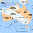
The climate of the south-west of Western Australia and the Western Australian Wheatbelt (termed together as the South West Land Division) is influenced by many global and local climate drivers.
Many seasonal outlooks are available throughout the year for use in the South West Land Division (SWLD), which includes the Western Australian grainbelt.
Much of the Western Australia's wheatbelt has experienced a very dry 2018–2019 summer leaving very little stored moisture at present (DPIRD, May seasonal report 2019). Yield potential varies signif
1. Sheep abortion and stillbirth investigation at Australian veterinary laboratories 2. A review of the revered Sarah Esme Blumer and her contribution to sheep science...